Scotland 2019
Intro
From March 2nd to 17th of 2019, Ben Clark and Jess Landing went winter climbing in Scotland thanks to the generous support of the wonderful Neil Mackenzie Adventure Grant. Their two week journey made a clockwise circuit beginning in Glasgow, West through Glen Coe, along the coast at Fort William (with a side trip to Ben Nevis), through the Isles at Skye, North to Torridon, East to Inverness, up high to Cairn Gorm, and finally back down to Glasgow. There were many fantastic snacks along the way as well, including numerous Full Scottish Breakfasts.
Unfortunately, due to the record-setting warm weather in February 2019, by the time of the trip the largest piece of naturally-occurring ice in all of Scotland couldn’t have been taller than 10cm. In short, no ice climbing was possible. Winter made a grand resurgence come March, though, and despite the lack of climbable ice, plenty of snow, cold, and adventure were found and enjoyed during the trip.
Our journey is discussed in 6 short stories below, each told by either Ben or Jess, with snide commentary from the other to be found in parenthesis throughout. Once again, we can’t overstate our thanks to the MacKenzie family, the Trust, and the UBC Varsity Outdoors Club, their kind support and enabling of the two of us to live out our dream trip. We would encourage anyone else who has an interest in seeing more of Scotland to apply for the grant – we hope our stories demonstrate that you don’t have to be the hardest crushing climber, you just have to have fun (and yes, sometimes in 80mph winds)!
Ben Nevis (Ben)
It was our first day of climbing on the trip, and with the best forecast the Highlands would see over the next two weeks, we jumped straight onto Ben Nevis, by way of the Cairn Mor Dearg Arete. In the midst of a downpour, we left Glen Nevis just before sunrise and by the time we arrived at the saddle, we were already slogging through boot-high slush and a whole lot of sheep feces (not an improvement).

Above: Jess below Ben Nevis on the way into Coire Leis
Nevertheless, we crossed over the pass and down into Coire Leis below the giant North East Face of the Ben. To our right, gigantic, snow-dusted cliffs disappeared up into the clouds above. By the time we passed the CIC Hut graupel stung our faces and the wind was so strong it could have toppled a sheep; but we carried on, up into the coire, the snow deepening steadily along the way.
We deviated from the standard Cairn Mor Dearg route due to avalanche conditions. Rather than taking the easiest route up a gentle snow slope to our right, our detour took us left. We tackled the blocky face at the back of the coire head on, going directly to the lowest point of the ridge, the vertex of the curve that stretches lazily from Cairn Mor Dearg to Ben Nevis.
As we climbed higher to the steepest part of the little face, we were quickly immersed in true Scottish winter climbing. Terrifying at first, but with a little knowledge of how to play the game it was actually kind of fun. There are few comforts as great as the sound of an ice axe sinking firmly into a frozen clod of sod. It’s like the sound of someone tearing the corner off of a piece of paper, superimposed on a faint thud. We moved slowly up the little face, climbing over and weaving between giant, snowy boulders, finding perfect turf sticks in all the crevices. [Jess: Personally, I was not as comfortable moving through this part of our climb. The degree of confidence Ben was finding in his sod sticks paralleled the magnitude of my nerves. Having had less time with my axes in the months prior than I would have liked, I was grateful for Ben’s patience and tips in navigating the somewhat steep and slick terrain].

Above: Jess climbing snow and frozen sod on the Cairn Mor Dearg arete.
Pretty soon, we wallowed up through a snowdrift and plopped onto the Cairn Mor Dearg arete, only 400m from the top of Ben Nevis. As we carefully shimmied, scooted, slid, and scootched our way along the snowy ridge, the clouds were beginning to clear and the wind was getting quieter and quieter. It was also around this time that the sound of graupel crashing against the underside of my hat brim finally quieted down enough that we could once again have a civil conversation.

Above: Jess on the Cairn Mor Dearg Arete
Eventually, our knife-blade arete t-boned into the broad South face. The scrambling became easier, the snow started to feel firmer, our efforts relaxed, and by the time we walked the last few metres to the summit, it was actually sunny! We practically skipped back down the tourist track to the Glen Nevis Hostel where ales and a dinner of scavenged-hostel-lentils awaited our return.

Above: Jess descending the Tourist Track towards Fort William from the top of Ben Nevis
(Not) Ring of Steal (Jess)
The morning following our adventure up the Ben, we decided to attempt the Ring of Steall, described as a “real classic mountain route combining the traverse of four Munros with scrambling along narrow, rocky aretes”. With a distance of 16 kilometres and an elevation gain of 1600 meters, we were looking at least a 9-12 hour day. A large objective, but with it only being a 15 minute drive from the hostel and the weather (potentially) in our favour, we screenshot a map, saved what we thought were detailed trip descriptions and were setting off from the trailhead by 8am.
After a mere 15 minutes on trail, I realized we were on the wrong side of the river [Ben: I disagreed]; so, we retraced our steps to the car, crossed a footbridge, and found the trail on the far side. The trail quickly shrank to barely a sheep’s path and before long, we were slogging through knee deep muck and peat moss [Ben: I repeat – I really, REALLY did not think this was the trail]. However, a quick check of the map confirmed we were headed in our intended direction. Sure, it didn’t look like your typical “well-traveled trail”, but we’ve all missed features that a guidebook has labelled “obvious” and after all, we were in the wilds of Scotland – how was I supposed to know what “well-traveled” meant in these parts? [Ben: I thought the guidebook reported that hundreds of hillwalkers hike to the nearby waterfalls every year… Maybe a sign?]
Pretty soon, our “faint-line-of-maybe-trodden-grass-and-mud” crossed over a stream [Ben: It was at least nice to wash the sheep feces out of my boot – hooray!] and took a sharp turn uphill. As we clambered up some precariously slick moss-covered roots and rocks, we soon found ourselves clinging to a slippery cliffside. After half a day of quintessential Scottish bog, we found ourselves halfway up the side of a sketchy hill, a cliff blocking any way forward, looking across the raging river below to see a few sheep walking along the perfectly manicured, well-defined trail, I had thought we were on, all on the opposite side of the river [Ben: those lucky little sheep even had a steel suspension bridge over there!]. At any rate, we enjoyed some nice views of Steall Falls on our return, shared a good laugh over a cappuccino back in Fort William, and I’m sure we’ll be all the wiser for it next time [Ben: And for the first time that day, we actually agreed on something – it was quite funny and cappuccinos are fantastic]!

Above: Steall Falls as seen from our dead end up a cliff.
The Buachaille! (Jess)
On our way to Fort William, we passed through Glen Coe, a beautiful expanse, dotted with classically Highland hills and one particularly prominent Munro. The top was dusted with snow and a grove of trees with a very cozy-looking cottage sat at its base – white walls, green roof, adorable. We later found out that this mountain was Buachaille Etiv Mor, one of the most loved of all the Scottish Munros. Wanting to climb it, we settled on a hiking route that traveled up the main coire, traversed along the various high points, and ultimately wrapped around and down the far side.
Our third morning in Glen Nevis, we made the 45-minute drive down to Glen Coe [Ben: twice, actually, due to a forgotten waterproof shell – essential!]. When we parked the car [Ben: For a second time], we were welcomed by some of the heaviest rain I have ever seen. An absolutely torrential downpour, rain drops blowing sideways – the kind of rain that makes lacing up our waterproof mountaineering boots and zipping up our coat that last thing you want to do. I think we made it about 45 minutes through the marsh, past the cottage (which we later learned is the Lagangarbh Hut, maintained by the Scottish Mountaineering Club), and up into the coire before the rain turned to snow, and our trail quickly disappeared.
We slowly and deliberately made our way up the corie, gaining the ridge with the help of our axes on the final bit of steep slope and in full-white out conditions. We knew route-finding could pose a potential challenge at one specific point on the ridge, “as the terrain has led some walkers to descend southeast from this point; note the turn in the ridge for the descent to the next bealach”, quoted the ever-reliable Walk Highlands. Even with that foresight, the use of our GPX file, and the GPS on our phones, we made this exact mistake; taking us for some unnecessary winter down-climbing only to have to scramble back up. Silver lining: At this point, I’m pretty sure I learned what it was to experience one of those secure frozen turf sticks Ben’s always rambling on about [Ben: I prefer a more loamy frozen sod, but to each their own!].

Above: Ben nearing the summit of Buachaille Etive Mor
After completing our traverse of the ridge (the correct one), we found the back coire, finally making our way down to mellowier weather and for the first time that day, the absence of any precipitation dripping down our backs. Saying goodbye to the Buachaille, we soon found flat trail and returned to the car, rewarding ourselves with what would become a favourite Scottish snack of the trip: Thai Sweet Chili Peanuts [Ben: Agreed, they might even be better than black pudding!].

Above: Ben taking in the views of Glen Coe from Buachaille Etive Mor
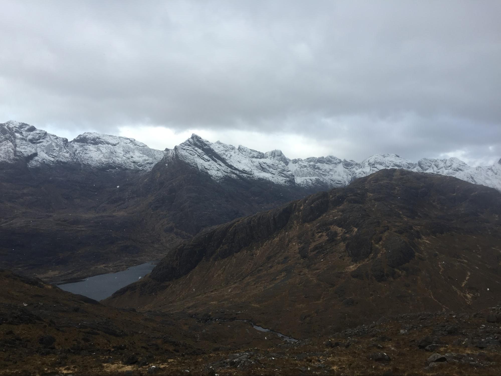
Isle of Skye and Camasunary (Jess)
Around the time we left Glen Nevis, an island-wide stormcloud had covered most of Scotland and a persistent wall of rain was expected for the next few days [Ben: Hey! I think I started one of my bits that way too! Does that happen a lot here?]. We spent a rainy day driving from Glen Nevis to our next destination: the Isle of Skye. Here, we tracked down a local fisherman’s hut and snacked on Scottish mussels and scallops, we walked around the picturesque seatown of Portree, and we settled into our Airbnb in the tiny “town” of Sligachan. Made up of a trailhead that leads into the Cuillin, a campground only open during the summer months, a two-in-one hotel and brewery, and a self-catering lodge (our Airbnb), calling it a town seems to oversell it. Nonetheless, the location was one of the most breathtaking of the trip and chock-full of charm: rolling hills, framed by the Red and Black Cuillin; lush, green, and peppered with the bubbling of the namesake river; the place we would call home for the next two nights, Sligachan, still remains one of my favourites from the trip.
The next morning, we woke up and Ben very sick [Ben: What a raging fever… I couldn’t stop shivering and woke up a few times thinking I was in the hull of a ship. I got to watch some BBC Alba, though, that was neat]. Having discovered a few days prior that venturing to Sligachan would take us close to Bell’s Bothy, I realized it would be a great opportunity to take advantage of some milder weather and see what kind of shape my running legs were in. With my running vest packed with electrolytes, stroopwafel, and an extra dose of tolerance for what was sure to be a classically Scottish, boggy trail, I left Ben a-snoozin’ and headed towards Bell’s Bothy at Camasunary Bay.

Above: The Black Cuillin along the route to Camasunary Bay
The trail to Camasunary Bay is a flat, well-maintained, rocky trail that meanders down the long valley between the Red and Black Cuillin. Inspired by the absolutely breathtaking views, I decided to tack on a detour a nearby hill, Sgurr na Stri. Accompanied by three adventuresome sheep, a few snowflakes, and a whole lot of wind, the trail led me high up, overlooking the sea, the Bay, and the Bothy below. I opted to take the most direct line and descended down a dirty gully, making some moves I can most accurately describe as “moss glissading”, and ended up wading through a knee-deep brackish river, ultimately arriving at the beach and Bothy.
Above: The Black Cuillin from Sgurr na Stri
Sand under my feet (and now in my shoes), I made it over to the far side of the beach and took a few minutes to look inside the Bothy, admiring the selection of games in the common space, the immaculately swept floors, and the beautiful sign hung in Neil’s honour. I remember feeling a bit of sadness because I wouldn’t be able to enjoy a night at the Bothy, and I made a mental note that a return trip to Scotland would be needed in order to return here and to further explore the expansive Bothy network. 
Above: View from Bell’s Bothy, towards Camasunary Bay and Sgurr na Stri
Returning to Sligachan, this time by the more direct footpath, I passed my first fellow human adventurers of the day. For a round trip of 30 kilometers, seeing only four people during that time felt incredibly special. Taking a relaxed pace, I ran back between the two ranges, taking in as much of their magic as I could, and day-dreaming about the new adventures I had to add to my to-do list once I returned home [Ben: Wow! So that’s what happened while I was in bed all day…]. Returning to the Airbnb, I found a well-rested and nearly recovered Ben. Naturally, I helped him put on all his coats and we hobbled over to the hotel’s bar, enjoying pints of Porter-like ale that had been brewed just next door and two, very poorly played games of chess.
Liathach (Ben)
In spite of being barely 1,000m tall, I find the mountains in the far Northwest of Scotland look impossibly huge. The broad, glacially carved valleys offer such grand vistas, and the giant, icy, striated faces look like they’re miles above treeline. Even people we spoke to in Inverness, Scotland’s northernmost metropolis, seemed to think this was the ends of the earth, and it certainly felt that way to me. We stayed at the hostel in Torridon, nestled deep in the heart of this wild and remote range. Rising straight up behind the hostel is Liathach, a 1000m high mountain massif containing two Munros connected by a long, steep, narrow ridge with a series of towers called the Fasarinen Pinnacles.
The forecast for our first day in Torridon predicted “considerable buffeting” and “any mobility becoming increasingly tortuous throughout the day”. But as we had learned so far on our trip, we had to keep tossing chips on the table if we ever hoped to win a hand. At dawn, we walked 3km down the “highway” (a single-lane road buried in a thick layer of sheep) to the East end of Liathach, in clear but windy conditions. As we walked, shaggy Scottish red deer watched us suspiciously from the deep shadows of a nearby pine grove. We found the trail and about an hour in, we started to find remnants of the previous night’s thunderstorms. A thin glaze of verglas coated the cliffs in a dull sheen, and there were numerous patches of hail, some waist deep! These hail piles made for some of the most unique scrambling I’ve ever come across, kind of like escaping an amusement park ball pit as a child.
We clambered up and over a few short steps and eventually scampered onto the crest of the ridge where we were greeted by incredible views of snowy, grand, and beautiful Beinn Eighe. A broad, U-shaped valley with a meandering stream at the bottom stretched out below. Dark clouds skated inland from the Atlantic just barely above our heads, many of them scraping their bellies over the nearby peaks, tendrils of mist swirling in the lees.
Above: Jess almost at the summit of Spidean a Choire Leith
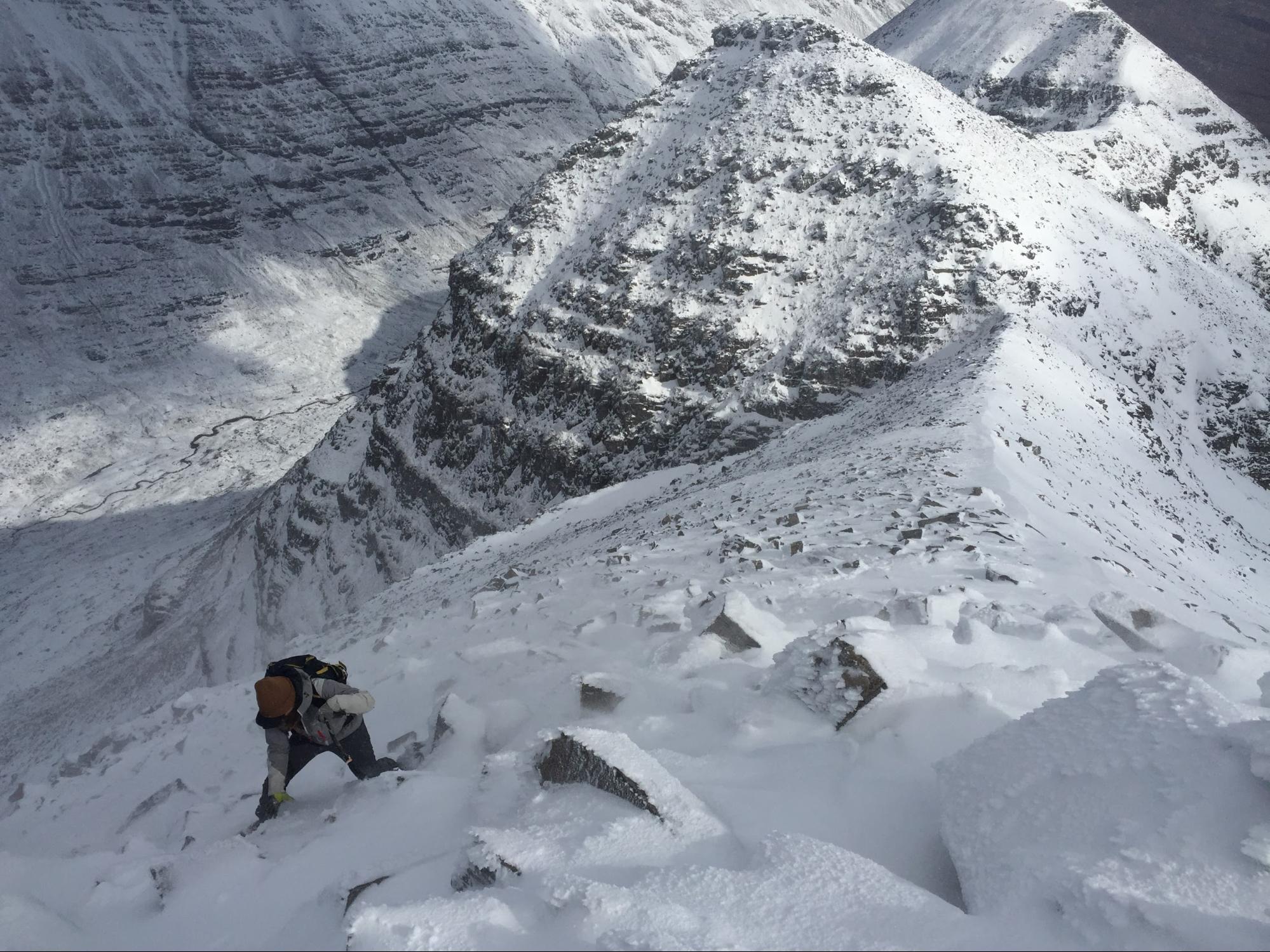
Another few hours of ridge-top plodding and rock hopping over the summit of Spidean a Choire Leith (our first Munro of the day!) led us to the crux, traversing the Fasarinen Pinnacles. We climbed carefully, always taking the time to double check our ice axe placements [Jess: sometimes triple check]. We discovered what the guidebook said to be true, that we could look down between our feet and see the road 1,000 meters below. We were fortunate to find supportive snow in all of the gullies, along with quality frozen sod on the small ridges. We scooted carefully around each corner, always surprised to find a conveniently placed ledge for easy passage around the next cliff. There was a brief lull in the wind and a few rays of sunshine streamed down between the clouds onto the brilliant, glittering snow slopes ahead of us, making for slow, serene, and beautiful climbing.
Above: Jess approaching the Fasarinen Pinnacles
Above: Ben crossing some ledges around the Fasarinen Pinnacles
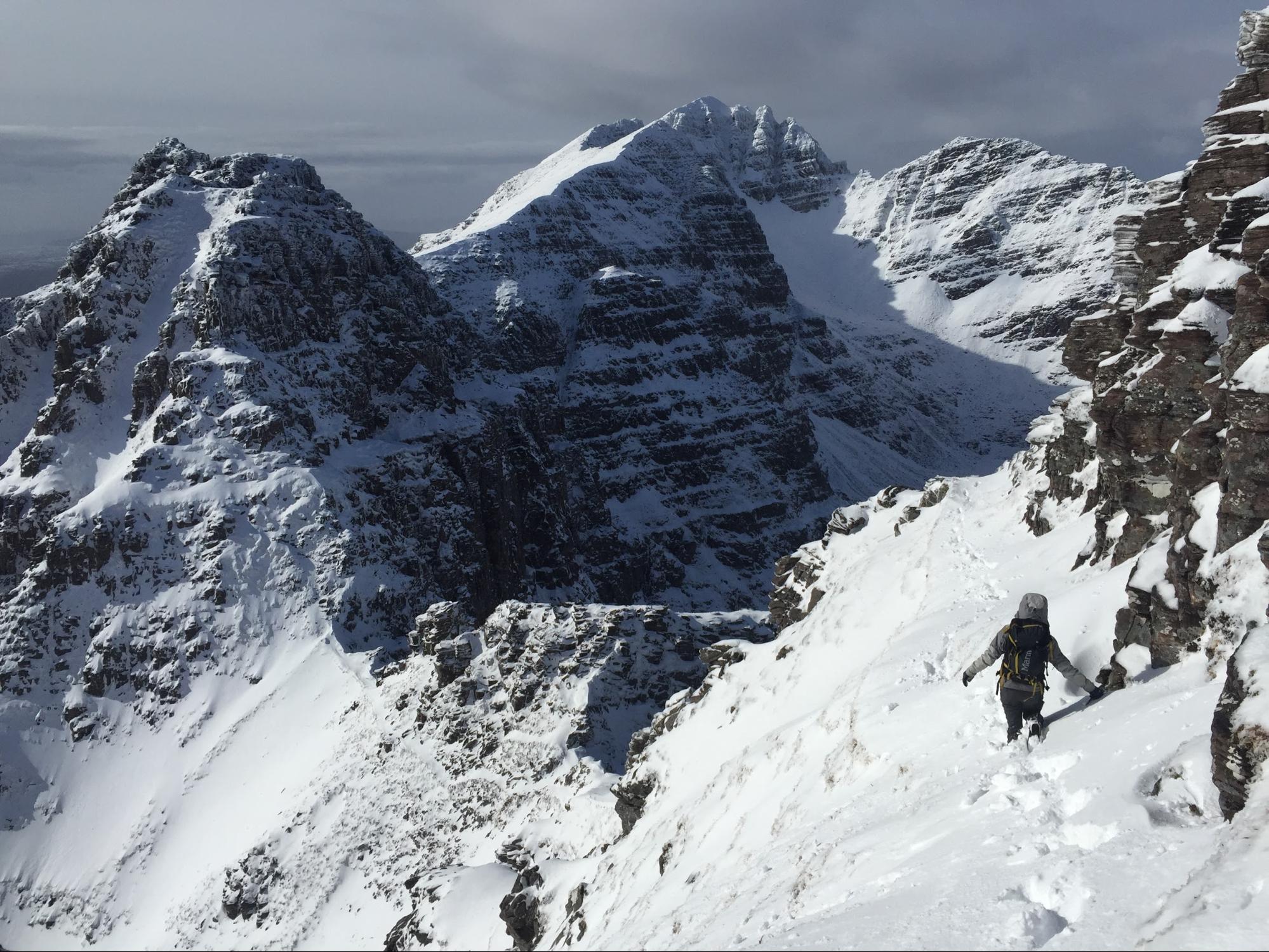
The fun didn’t last forever, though. We wrapped around the final pinnacle and slowly trudged up to the summit of our final Munro, as a new weather regime arrived and the wind began to sting our faces, occasionally trying to knock us over, as if we were bowling pins. We began our descent just as the clouds covered the entire Western coast of Scotland in another giant storm that was certain to last for days.

Above: Ben and Jess on top of Liathach
Taking time to relax, the next day we weathered the storm in the little coastal village of Applecross. I don’t think I’ve ever felt more cozy than when I was there at the Applecross Inn, a warm fire raging, sleet coming down sideways out the window, warm sticky toffee pudding in my belly, and good memories of fun winter adventures fresh in my mind.
Cairngorms (Ben)
When we arrived in Aviemore, giant snowflakes the size of golf balls were plopping down out of the sky, making little squishy sounds as they hit our windshield. By this point in our trip, we had hoped that some wee trickles of ice would have fattened up into sheets just thick enough to hold an ice axe. Unfortunately, those golf balls falling down in Aviemore were falling even heavier high on Cairn Gorm. If there had been a trace of ice, by now it was certainly covered in a few feet of fresh snow.
Nevertheless, the following morning, lured by a break in the storm, we decided to take the ice tools for a walk to the historic Coire An t’Sneachda. Since it was our final day of climbing, it was a really tough call to make, but upon arriving at the Coire, avalanche conditions were too severe for us to feel safe climbing our intended route. However, we decided there was still time for a little adventure and climbed up a small, wind-scoured ridge to the high Cairngorm Plateau, returning by an alternate route.

Above: Jess approaching Coire An t’Sneachda
As we climbed, the wind picked up and the bits of ice and snow that our boots knocked from rocks, rather than falling downhill, would instead would go skittering uphill, blasting off over the ridge, where presumably they’d land in Glasgow later that day. Once on top of that desolate plateau, it was hard to stay upright, and we could barely see 4 metres through the cloud and stinging ice crystals. After an hour or two of persistent staggering, troublesome route-finding, and the occasional crawl, our efforts brought us stumbling down off the plateau and back towards our hostel. This time, to recover from our ordeal, we grabbed a meal at the Mountain Cafe in Aviemore, and spent some quality time catching up with Jess’ aunt who had come to join us for our final night in the Cairngorms. A hot meal, by a warm fire, with gigantic snowflakes drifting gently outside the window – some of my fondest memories of the past winter.

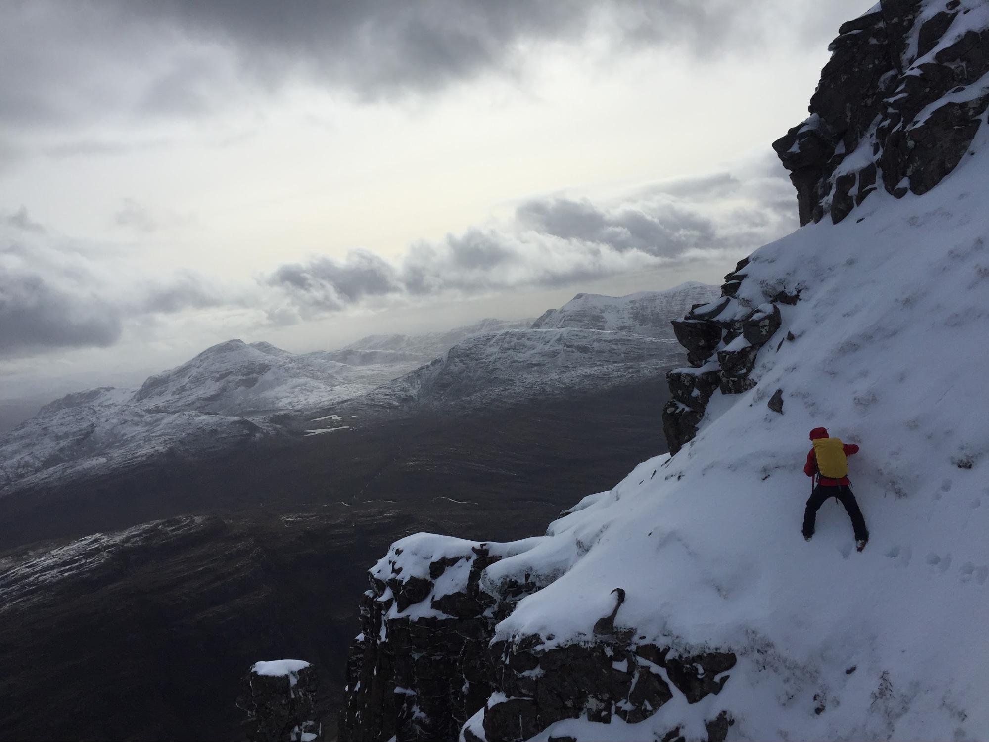
Above: Ben almost on top Cairn Gorm with Coire An t’Sneachda in the background.
It was bittersweet to end our trip without having climbed any ice, but that’s the way it goes for us ice climbers some days. In a weird way, because we were forced to make things up as we went, I almost think we chose more fun adventures than we’d have ever dreamt up at home. We learned a thing or two about winter hillwalking, scottish treats, Gaelic, hospitality, whiteout navigation, non-whiteout navigation, sheep, and maybe even ourselves. At any rate, it was certainly the most fun thing we did all winter, and the adventures are ones we’ll never forget!
Appendix – Extra Photos

Above: Gnarly trees and thick moss somewhere near Steall Falls…

Above: A Highland Cow Jess was super stoked about.
