Our original application was for a cycle trip to the southwest of France cycling towards the Spanish border. However, we had to change this at the last minute as the whole area was sealed off due to large forest fires which meant that the original route had been closed and many campsites along it. Climate Change in action and this theme continued throughout our trip and feed into our John Muir Award Project.
We followed part of the EuroVelo 6 route, the section we chose to cycle started at Tours and finished in Nantes, it was a cycle ride of approximate 337km over 7 days, averaging 48km per day.
It was indeed a challenge for all, we carried our own panniers with equipment, clothes, and food with the aim of being as self-sufficient as we could be. The route followed most of the time the river Loire and along designated cycle paths for around 70% of the journey.
Day by day summary.
Friday 19th London to Tours
We just about all meet at 16:30 at St. Pancras International Station all of us ready for our adventure, if not a little nervous at the same time. We set off for France at 17:30 pm, two hours later the Eurostar arrived in Paris Gare du Nord from there we took the R3 to Austerlitz station the other side of the Seine, Avalon really loved the doorhandles on the R3. We had a little wait here before the next train, so we took a break to eat our packed dinners and we had a few fries on the side. The train we took to Tours was very plush, sofa like seats and we were the only ones in the carriage. The journey lasted around two hours and we arrived there at 1.15am. From the station it was a good 15-minute walk to the hotel, and we all struggled carrying the pannier bags as they were very awkward. By the time everyone was settled, and, in their rooms, it was already 2 am and we all fell asleep very quickly.
…………………………………………. Download full report and photographs : loire2
Monday22nd
36km to rock somewhere outside Gennes
We woke up refreshed and ready for a new adventure, Monday breakfast was the staple croissant and applesauce after which we packed up the tents and prepared the cycles for the day. Today was probably the easiest cycle ride as we continued to follow the river and we seemed to quickly reach the town of Gennes. We had lunch here and then we had some free time to go and wander around the town Alex went off and discovered a delicious bakery … which we all then went to find. Importantly we were able to stock up on supplies and goodies for the next few days. Some of the group were a little late getting back …they got lost apparently ..!
We cycled a few more kilometres to a small village with some bakeries, we stopped here for some drinks as it was a really hot day, Jake tried to make some weird mix with the drinks that didn’t go down to well. After another 2 km, we arrived at the place we would be spending the evening, early enough to enjoy. Hotel for the evening was a structure made of rocks “Dolmen de la Pageire”, we were wild camping this time we were more prepared and knew what to expect the rock was an amazing experience. It had good sleeping conditions and great climbing; it gave us a chance to build even more skills and learn from each other. It also had amazing views of stunning fields and forest. We explored the forest which was very enjoyable and where we found two chairs. After dinner we were first set a challenge by Alex and Celia where we were in teams and had to label the bike parts after which we looked for different ways to climb the rock which strengthened our team building skills as we supported each other. We ended the day in a relaxing manner talking and listening to music while watching the sunset. We then went to sleep surprisingly comfortable.
……………………………….
Thursday25th
62km to Saint Herblain
Thursday, the second longest day of cycling and everyone woke up with lots of ants in their tents and in their panniers. We emptied everything and tried to banish all the ants with limited success, we were to find out later. Having completed this task, we ate our breakfasts and prepared for the cycling.
We cycled along by the river all morning which was very pleasant until we reached a very conveniently placed supermarket at the end of the path, so we purchased lunch and ate it in the local park where Avalon found more trees to climb, and Avantika found some very sour grapes. We spent a little bit of time here before the afternoon cycle into Nantes. This cycle again was by the river and pleasant until about 3km outside Nantes when we suddenly started noticing a lot of fly tipping and burnt-out cars, to be honest we all found this piece of path a little scary. Having got through this we then arrived in Nantes and stopped for a quick water break where some of the young people played chase, Jake used his parkour skills and jumped over the riverbank wall… but then was unable to climb back up it and we had to put Operation save Jake into action.
Jake having been rescued we continued to Saint Herblain where we would find our accommodation for two nights. The cycle from Nantes was a little industrial to start with but then we found our way into a nature reserve and had to cycle along a boardwalk which was really fun.
Have unloaded the bikes we opened the tents in the garden to dry them off a little and Alex and Celia went to get some food. We had a feast that night pizza, chicken, salad and to finish off ice cream. After this we collectively choose a film to watch and relaxed with popcorn. We were all happy to be sleeping in beds that evening, although Alex and Celia slept on the floor in the lounge.
………………………………………………….
Saturday 27th
Travels around Nantes
Saturday was the last full day of the holidays and we had to leave the house as we were staying in Nantes that evening to make catching the train easier on Sunday morning as it was at 5.30am.
We were staying in a lovely apartment about 15-minute walk from the station and we all had a good night sleep even if it wasn’t for very long as Alex woke us up at 4:30 am.
This diary just gives a taster of all the things we learnt and experienced on this trip, and we all feel that we have grown in some way having completed this amazing Journey.
We had a five hour wait in Paris …but finally made it back to London with many stories to share.
Young people’s feelings and thoughts about the trip
“This trip showed me another side of the culture of the French. It allowed me to truly experience life as a local which I would never have seen if it wasn’t for this trip. We pushed past our previous thought to be physical limits through kindness and encouragement.
We went through a short trail, where multiple people kept on falling of their bikes, but through perseverance and prioritizing the team goal over one’s own (which we learnt from Alex) we successfully made it through to arrive to a warm bed and running water (which this trip allowed me to see its value).We all had lots of fun on this trip and got to learn a little about ourselves as a bonus.”. (Hannah)
“I’m very proud of myself for cycling, such a long way and distance in such a short amount of time and sleeping out in the open and in the cave” (Yameen)
…………………………………… Download full report and photographs: loire2
Parents feedback – it is easy as a worker to forget how these trips can change the prospective of a young person and the feedback we received from the parents after this trip really helps to high light the necessity for all young people to have access to such schemes no matter their family background or parental income.
………………………………….
“I’ve been meaning to write to you about how the trip away has impacted Avalon’s life.
She seems different, more buoyant, more confident, more resilient, more positive, less anxious, and much much happier. Avalon seems to have settled more into herself and for the first time actually likes herself. School is presently ok; this has never happened before!!!!
I wish all young people who struggle could have the same opportunity. Experiences like this can raise people up and out of their darkness and give them the confidence and resilience to make positive life choices leading into young adults”. Linda (mum)
…………………………………………………….
Jakes Mum
“I feel that Jake learnt some valuable lessons on this trip emotionally and physically, he has matured because of them. He Developed more independence but being away made him value his family more. The trip improved his confidence and self-esteem because he has more self-belief.
He’s gained more motivation to take parts in multiple sports clubs and activities on a weekly basis which is so important for him. As he has a lot of nervous energy and playing sports and cycling keeps him busy and fit and has helped with his focus at school. I think he’s learnt a lot more about what his body needs to function as an athlete and is now taking more of an interest in nutrition to fuel his body. I’m so pleased he took part”. (Laura)
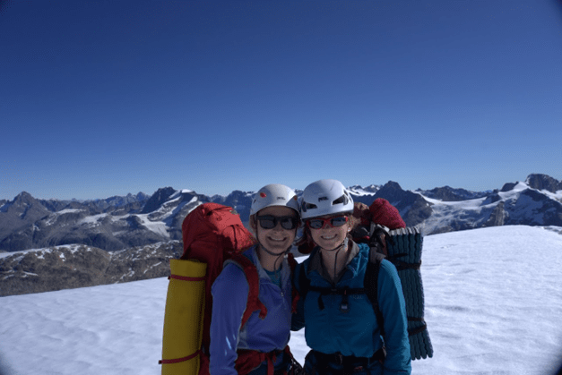
Greenland 22nd July- 7th August 2022. Hannah Mortlock, Tom Litchfield and Bethany Carol from St Andrews Univeristy Mountaineering Club alongside the Scottish Arctic Club and with the support of The Neil Makenzie Trust.
On the 22nd July, Bethany Carol, Hannah Mortlock and Tom Litchfield flew from Glasgow to Keflavik (Iceland) to join the Scottish Arctic Club’s 50th Anniversary Expedition to Tasiilaq and Ammassalik Island. After landing in Iceland, we enjoyed walking around Reykjavik before meeting the remainder of the 25+ other expedition participants in Reykjavik City Airport the following morning. After a slight delay, we boarded a propellor aeroplane to Kulusuk, East Greenland. From here, we transferred by boat to Tasiilaq, the largest village in East Greenland, where we were based for the next few days.
While in Tasiilaq, we got to know many of the other Scottish Arctic Club members (many of whom had different objectives for the expedition, so we would not see until the flights home), stocked up on supplies, ate a delicious meal and watched the finals of the East Greenland football competition. We also walked up Sømandsfjeldet (a 718m hill behind Tasiilaq).
After this, we were transferred by boat up the Ammassalik fjord, then Ikerasagssuaq fjord to a granite cirque (65.91258694575762, -37.579071692925346), identified by Scottish Arctic Club members. We were initially alone in the cirque for several days and enjoyed the solitude and remote feeling (it was a 90-minute boat ride from Tasiilaq and over 5km from, and out of sight of, the nearest settlement (Tiniteqilaaq)). After that we were joined by six members of the Scottish Arctic Club expedition and enjoyed their company and the chance to learn from their expertise.
While in the cirque, our primary aim was exploration, hill walking and mountaineering. Active for most of the 10 days we spent in the cirque, we particularly enjoyed climbing (and a planned bivouac on) the West Flank of Pt. 2000 (we yet to find any details of previous ascents of this mountain), the West Ridge of Nîniartivaraq (the big ‘N’) and making an attempt (we reached a fore summit to find the final 80m to the summit to be extremely loose and steep) on the South Ridge of Pt. ~1120 (we yet to find any details of previous ascents of this mountain). We had an enjoyable afternoon multipitch rock climbing and loved the chance to spot wildlife (we saw Minke Whales regularly in Ikerasagssuaq fjord and Arctic Foxes sniffing around our food barrel most evenings. We also successfully fished in the fjord, catching trout and cod.
After a fantastic 10 days in the cirque, we headed by boat back to Kulusk, where we enjoyed the supermarket, and then flew back to Iceland. In an incredible, but manic, layover with a friend (who now lives in Iceland) we were thrilled to relax in a geothermal pool before heading out in the evening to see the volcano, which had started erupting two days before: A truly awe-inspiring way to cap off an incredible trip. Exhausted but hugely satisfied, we arrived back in Glasgow on the 7th August. We are hugely grateful to the Neil Mackenzie Trust for their incredibly generous support of this trip. We had a hugely inspiring, enjoyable and educational experience and are all eager to enjoy further international expeditions and, where possible, to assist other young people planning their own expeditions.
We are so grateful for this opportunity and the extremely generous support we received from the Neil Mackenzie Trust, so thank you!
Every charity, however large or however small, relies on its supporters to help provide funds to carry out their work. We are grateful to all our donors for all that they do for us. This summer, we are particularly grateful to Duncan Grant, one of Neil’s greatest friends, for taking on the Tough Mudder Infinity Challenge. I am not sure that it will be fun, but it is certainly the sort of “entertainment” Neil himself might have taken part in. Immense thanks to Duncan, and everyone who has supported him. Already donations have exceeded £1,000. Please support Duncan, if you can, by donating:https://www.gofundme.com/f/tough-mudder-infinity-challenge-for-neil-mac
Reaching out to those who most need support.
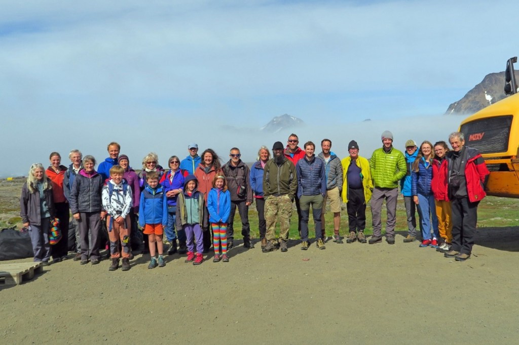
Over the last seven years we have helped people from all walks of life to gain new outdoor skills and undertake adventures and expeditions all over the world. Now, with the help of some of our new partners, we feel more able to reach the individuals who can benefit from our support most. This summer we are delighted to be supporting a group of young people from Inner London, who are heading to France to cycle part of La Velodyssee for 8 days with their group leaders, whilst completing their John Muir Trust award. We are also working towards a grant for a family of 6 from Kintyre (including one severely disabled child), to have an active break to learn more of their local history and culture.
We are continuing our partnership with Glenmore Lodge, offering enhanced grants to appropriate individuals to carry out skills training near Aviemore. We are also working in discussions with Aban and The Martin Moran Foundation to help young people achieve new goals in the mountains of Scotland.
VOC Neil Mackenzie Adventure Grant
Nina, one of our intrepid adventurers from the University of British Columbia Varsity Outdoor Cub (VOC) has recently returned from Namibia where she has been developing a new multi-pitch climbing route on the Spitzkoppe formation in the Namib desert with her brother, Cole, and the support of three others.
While we await her full report here are a few of her photos.
“We worked so hard and I learned so much, truly it has been an experience of a lifetime” – Nina Sky
Robertson
Iceland
Our other 2022 VOC adventure was to Iceland over the Summer Solstice. The aim, of students Linda Kiritchkov and Mason Slavner, was a 7 – 8 day hike along the 100km combined Laugavegur and Fimmorouhals trails with plans of side trips of mountain summits along the way. The adventure would also include exposed class four scrambles, mountaineering and glacial river crossings. “Iceland draws our attention not only because of its high northern latitude, but also because of the shockingly varied geology and breathtaking views.”
We look forward to receiving their report before too long.
Events: Watch this space for future fundraising events ………………..
Like Amazon Smilehttps://smile.amazon.co.uk/ , Easyfundraising is an easy way of helping your favourite charity raise money – and you don’t even notice! Join in, by following this link https://www.easyfundraising.org.uk/invite/IR64TF/ , search for The Neil Mackenzie Trust and click “support this cause” and soon we will be benefitting when you buy online from many of the UKs most popular retailers.
We are now a recognized charity with Maximum Adventure. Another way to raise funds for us!
A big thank you to all our supporters. Please keep in touch and let us know your fundraising ideas!
Applications: If you are over 14, applications can be made at any time for Expedition Grants, Skills Training Grants and Health and Wellbeing Grants – contact us through the website, let us know your plans and we will send you an application form.
Our thanks go to local artist, Ros Rowell for generously donating this beautiful watercolour of a Highland River for our fundraising event on 2nd April. (Apologies for any misrepresentations caused by the poor photography!) It will be auctioned on the night – but we will happily accept bids beforehand. I am happy to say that we have had our first bid of £30, but we hope that there will be plenty more bids to come! It is worth a lot more than this! To bid contact us. We will update bids here and on our facebook page.
The event is a ceilidh dance and will be raising money for Disasters Emergency Committee Ukraine Appeal and The Neil Mackenzie Trust. The dancing will be to the Dunphail Ceilidh Band and the venue, just 7 miles south of Inverness, the Strathnairn Hall, Daviot, IV2 5XL. There will be a tombola and a raffle and we ask you to bring plenty of cash so that you can win some of our many amazing prizes. Please also bring your own drink and, if possible, some food to share (finger foods are best). We will be following all Covid guidelines in place at the time and we ask you, please, to be Covid aware and test before you come.
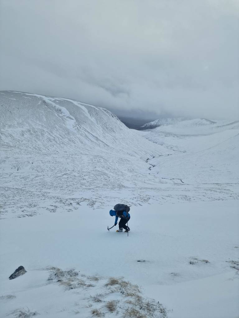
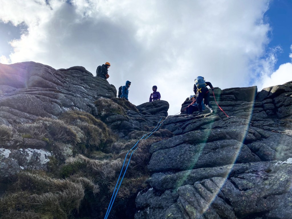
I attended Winter Mountain Leader training run by Scotch on the Rocks Guiding in the Northern Cairngorms. Attending the course seemed like the next logical step after completing the Summer Mountain Leader and Rock Climbing Instructor awards. I was also keen to improve my personal skills in the winter mountains and learn how to look after and teach relative novices in the winter hills, building towards delivering winter hill walking for my university mountaineering club.
Day 1:
After meeting fellow participants and the instructors, and a lecture on the Be Avalanche Aware process, we focussed on improving our personal movement skills to be a role model to future groups and began to think about how and where we could teach these skills to beginners. On our journey around Coire Cas, we also discussed navigation and softer skills, such as group management and leadership. The day got off to an unusual end, as we assisted with the rescue of a hill walker who had fallen down the Coire Cas headwall. This was a really valuable learning experience, as I had never been involved in a ‘real life’ rescue scenario before, and we were all glad to hear that the walker hadn’t sustained any serious injuries.
Practicing using drills and games to help ‘clients’ get used to moving with crampons on
Day 2:
The main focus on day 2 was winter navigation, particularly how we can use changes in slope aspect and gradient to accurately pinpoint present position. This is particularly useful in the winter as many features we would rely on in the summer (e.g., paths, burns and lochains) are buried by snow.
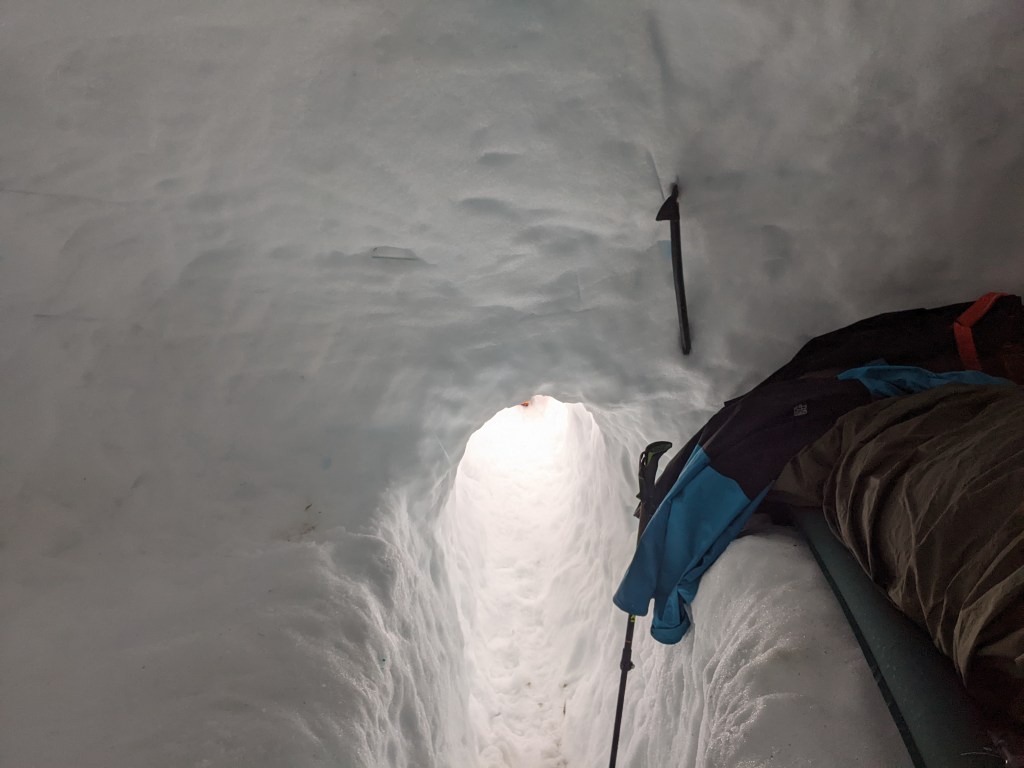
After heading into Coire an t-Sneachda, we explored movement skills on steeper ground by traversing beneath the Mess of Pottage up to ‘Windy Col’, discussing the limits of the Winter ML remit. We then journeyed into Coire Domhain, where we dug emergency shelters as the sun set. This was something else I hadn’t done before, and I enjoyed digging it and could see how effective they can be.
Once it became darker, we put our new winter navigation skills to the test, journeying out towards Ben Macdui and finding lots of slope gradient/aspect changes around the Garbh Uisge Beag burn. This was a very new approach to navigation for me, and something I’m looking forward to practicing ahead of my assessment, and putting into use on personal hill days.
Day 3:
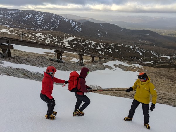
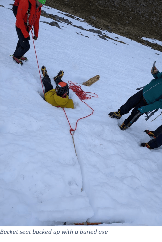
Day three started with an avalanche planning exercise, practicing using the BAA process to plan safe days out faced with challenging avalanche forecasts. This was a really valuable exercise, which highlighted the challenge of meeting possible client expectations (e.g., to ‘bag’ Munros) while maintaining suitable safety margins. After this, we headed back into the Coire Cas headwall area to practice snow anchors and ropework. We covered bucket seats, buried axe and snow bollard anchors and how these can be used to manage short steeper sections, client problems (e.g., crampons falling off) and increase client confidence.
Day 4:
On the hunt for more snow, we headed across to the Nevis Range, where we used the Gondola to access higher elevation snow patches around the Nid ridge on the east face of Aonach Mor. We explored how to manage groups on steeper ground, starting with step cutting, before moving on to consolidate yesterdays ropework and snow anchors. After this, we covered ‘stomper’ belays and confidence roping, before going on a journey up some steeper ground where we discussed heuristic factors and how we would manage imaginary clients on the terrain we were on. The day finished with exploring how we could employ the rope to manage edges, invisible due to bad visibility.
Day 5:
Day 5 started with a brief return to wintry conditions with some high-level snow, lots of rime ice forming and generally poorer visibility than the previous days. The instructors took advantage of this to do some more navigation practice, heading from the Ciste Car Park to the Ciste Mhearad via the top of Coire Laogh Mor and Cnap Coire na Spreidhe. Once we arrived at the Ciste Mhearad, we dug snow pits and assessed how we can use them to evaluate snowpack structure to identify avalanche problems and snow grains, discussed trenching to quickly evaluate slope stability, practiced an avalanche casualty search and recapped the use of a rope near ‘invisible’ edges. On the way back to the cars, we practiced searching for lost group members, highlighting the importance of clear initial briefings to clients (before they get lost!) and intra-team communication while conducting the search, and discussed the instances where line and box searches are more appropriate.
Day 6:
On the final day, we covered the four required ice axe arresting methods in Coire na Ciste: Sliding feet first on the front; Sliding feet first on the back; Sliding head first on the front; Sliding head first on the back. The importance of giving near perfect demonstrations was again highlighted and we considered how best, and where, to teach these to future groups. After this, we headed back down the hill for group and individual debriefs.
Overall, I’d like to thank Ian and Dave from Scotch on the Rocks for delivering an extremely informative and enjoyable week so well and for making a decidedly un-wintry conditions feel pretty wintry, and to the Neil Mackenzie Trust for their incredibly generous support- it really helped me to attend this course. I left looking forward to putting all the skills I’d gained and refined over the week to good use while consolidating and with my eyes on an assessment next season. I’m also planning to practice teaching some of the skills to friends and members of my university club, giving me the chance to build further upon my winter hill leadership skills, and hopefully increase their competence and confidence in the winter hills.
Assessment – one year on
After offering very generous support with my Winter Mountain Leader Training, I am really grateful that the Neil Mackenzie trust extended further support for the next stage in the Winter ML journey: The assessment.
After a largely good season of winter hill walking in preparation for the assessment, I arrived at the start point in Aviemore with a healthy amount of trepidation. Well aware of the reputation of the Winter ML assessment, I went into the assessment expecting a challenging and stressful week. The assessment was certainly this but it was also enjoyable and rewarding to put my skills to the test against a well-defined standard.
The first two days of the assessment were spent working through how we would teach novice and intermediate clients how to use an ice axe and crampons, and how best to manage them on slightly steeper terrain. We also covered “problem solving” both with and without using the rope- I particularly enjoyed seeing how my fellow candidates dealt with the various issues the assessors threw at us, and I certainly learnt from their experience throughout the assessment in addition to that of the assessors.
While there was no doubt that this was certainly an assessment, I really valued the learning opportunities built into the assessment- The chance to learn from the assessors, who are all extremely skilled, experienced and knowledgeable mountaineers, leaders and instructors was fantastic- for example, on the first day we were given feedback on our snow anchors to bring them up to “gold standard” and the chance to put this feedback into action on the second day.
The meat of the assessment, and the bit I was most anxious about, occurred on days three and four: The snowhole expedition. Traditionally, this would have been a three-day, two night expedition, but recent changes to the syllabus after the pandemic meant that the length of the snowhole expedition (and whether one happens at all) is determined by the course director. I was really pleased that a snowhole expedition was included in our assessment to get the “full experience”. After a briefing in Tiso Aviemore, we made our way from the Cairngorm Ski Centre car park to find pre-dug snowholes in Coire Domhain. Having visited these snowholes, which were very sizeable (dug by the military) already this winter, I was excited to return and sleep in them. However, the snowholes had sagged and collapsed quite a bit during a warm spell and now re-frozen (in places with hard water ice), so digging them out to be a usable size again was quite a task, taking many hours.
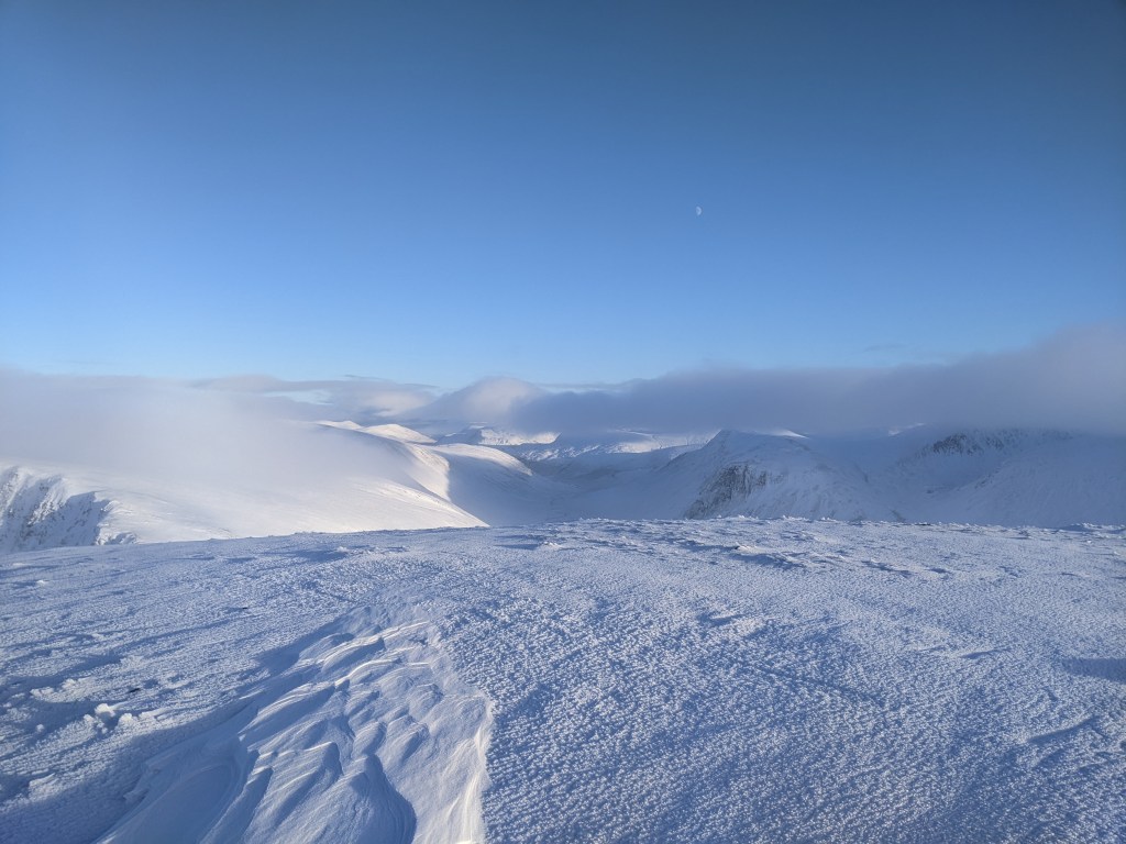
After dinner, we headed out on night navigation towards Ben Macdui in windy conditions with poor visibility- this was a good challenge! The next day we had a great mountain journey, in fantastic weather, from Coire Domhain contouring around Cairngorm before heading down to The Saddle then along Loch Avon then heading back to the snowholes in Core Domhain. This was brilliant and a great way to tie all the syllabus aspects together, assessing how we dealt with situations on a real mountain journey, for example evaluating avalanche hazard, dealing with iced up rocks and burns in spate.
We ate dinner in the snowholes then headed back to the car park in burly conditions doing a bit more night navigation. Remarkably, over the course of the expedition, I managed to break three zips: I am still trying to work out how I managed to do this and whether this is some kind of record!
On the final day we thought about the element many beginner winter skills groups are particularly keen to learn and practice: Ice axe arrests. We considered how best to teach the whole progression from self-belay to all four types of ice axe arrest (sliding feet first on your back, sliding head first on your back, sliding feet first on your front, sliding head first on your front) which was again good fun to learn the different ideas all the other candidates had about this and to learn from their experience.
On reflection, I certainly put too much pressure on myself throughout the process and this level of stress definitely affected my performance during the assessment. On the whole, the assessors did a great job of creating teaching opportunities during the assessment which was really valuable, in addition to their feedback.
Article adapted from an entry originally submitted to the American Alpine Journalby Nick Hindley
Pangea 2021: Disaster Fauna (5.11- A0, 600m) First Ascent
————–
On August 15, 2021, Harlin Brandvold, Duncan Pawson, and I loaded our gear into the helicopter to make our return trip into the isolated valley of glacier-clad granite bigwalls that had come to be known as Pangea. We had flown into the valley once before in 2019, with the goal of exploring and establishing routes on the vast granite faces nestled deep within Foch-Giltoyees Park, along BC’s central coast. Having spotted the unnamed valley on Google Earth and lacking any photographs or reports of prior human travel into the valley, our initial helicopter flight was a huge gamble. But as we flew southwest from the town of Terrace, the rocky foothills eventually gave way to rugged, glaciated peaks of granite. The unclimbed 1,200m north face of Gilt Peak (1,893m) soon crested into view, marking our destination on the horizon – that has to be one of the largest granite faces in the Coast Range, I thought to myself. The scale of the wilderness embodied a prehistoric aura that would later earn the unnamed valley it’s nickname, ‘Pangea’.
Loading up big red, once again. Terrace, BC.
The unclimbed north face of Gilt Peak towering on the horizon.
Having been awarded the Neil Mackenzie Adventure Grant in 2020, this trip was a long time in the making. Despite our best efforts in coordinating with the local First Nations and BC Parks, park closures of Foch-Giltoyees ultimately forced postponement of our 2020 trip. For months leading through summer 2021 park access remained an uncertainty. In a push to gain approval to access the remote area during covid times, Harlin inadvertently became an intermediary amidst the ongoing covid bureaucracy between park stakeholders. After many emails back and forth, the park was ultimately opened and Pangea 2021 received the green light.
The initial objective for our 2021 return trip had been to complete our partially established route Lizard King (5.10 C1, 300 m, so far…), which climbs a dyke and splitter chimney, perfectly bisecting the 700m face of Extinction Wall, along the northern flank of Gilt Peak. An incoming storm, which would ultimately end our trip, had thwarted our efforts on the wall in 2019 by forcing retreat from our portaledge camp atop pitch eight. Unfortunately 2021 would prove to yield familiar environmental challenges as we arrived to a wall soaked with the melt of a prior season of high snowfall – ending our bid before it began.
Through the spotting scope we scanned across kilometers of granite in every direction in search of a feasible new objective. We panned northward from Extinction Wall to Cambrian Wall; a relatively smaller feature between Chiq Peak (1,741 m) and Giltoyees-Ecstall Pass. There are no shortage of potential route options, but having been humbled here before – most notably on our 21-hour epic establishing Flight of the Dodo (5.10, 350 m) on Cambrian Wall in 2019 – we tried to keep our ambitions in check. We decided to spend our first climbing day exploring a route up an easy slab ramp up the east flank of Chiq Peak. The result was a successful warm-up day and new route; an easy ramble of mostly mid-5th with some 5.8 moves to the top of the slab. We named the route Planktonic Relationship (5.8, 450 m) for its mostly rambling character while not actually going anywhere significant. Comfy shoes and bug spray are highly recommended.
The FA of Planktonic Relationship (foreground), and the massive N face of Gilt Pk (left) and Extinction wall (right).
The following morning, with a warm-up climb under our belts, we felt more willing to set out for a larger object. So yet again, we scanned the vast granite walls through our spotting scope. Eventually, a prominent buttress on the south face of Chiq Peak caught our attention; featuring a succession of discontinuous cracks and corner systems spanning most of its 600m relief. A promising line! We each loaded up ropes and racks and set out across the valley that same morning, excited for the potential objective ahead, despite the significant unknowns that it may hold.
Bivy at the base of the wall, looking on to a moody Nautilus Wall and Extinction Wall.
Only about 600 m north-northwest of our basecamp, atop a snow slope and some fourth class scrambling, we reached the base of the wall. Wasting little time, I tied in, pulled over a small roof, and pieced together the first pitch. Then, Duncan and Harlin each led a successive pitch; tiptoeing across a basalt dyke, then out onto slabby face climbing, bolting on lead as necessary. The slab featured some of the most peculiar and undulating granite I had ever seen: ripples, chickenheads, and pods. Features that we later learned could result from hydrostatic pressures at the interface of rock and glacial ice. This made for excellent, balency 5.10 slab climbing to Harlin’s bolted anchor above. Darkness approached and we fixed lines to the base and descended back to camp to wait out a storm the following day. We spent our weather day huddled under a blue Canadian Tire tarp we had rigged up to a boulder. We ate well and enjoyed festivities prepared by the Ministry of Fun and Games (Nick); Jamesons whiskey and
Only about 600 m north-northwest of our basecamp, atop a snow slope and some fourth class scrambling, we reached the base of the wall. Wasting little time, I tied in, pulled over a small roof, and pieced together the first pitch. Then, Duncan and Harlin each led a successive pitch; tiptoeing across a basalt dyke, then out onto slabby face climbing, bolting on lead as necessary. The slab featured some of the most peculiar and undulating granite I had ever seen: ripples, chickenheads, and pods. Features that we later learned could result from hydrostatic pressures at the interface of rock and glacial ice. This made for excellent, balency 5.10 slab climbing to Harlin’s bolted anchor above. Darkness approached and we fixed lines to the base and descended back to camp to wait out a storm the following day. We spent our weather day huddled under a blue Canadian Tire tarp we had rigged up to a boulder. We ate well and enjoyed festivities prepared by the Ministry of Fun and Games (Nick); Jamesons whiskey and Fireball paired with crib and yahtzee.
.
Bear prep and Gill the Bigwall Fish.
I awoke the next day to a gloomy valley with low clouds rolling past it’s seeping walls. We each peered through the spotting scope to take stock of the terrain above and set milestones for the following days. After many hard-learned lessons, setting achievable goals had proven to be one of the most important pieces of advice I had received for first ascent climbing. We set off, having packed another 200 meters of rope, an ungodly amount of rack, bolts, and drill batteries as well as our bivy gear, prepared to spend the next few nights camped at the base of the wall. Shuttling gear to the base took the full day. Hauling heavy pigs proved to be the challenge of the day. We rigged up a haul line to drag them up the steep snow slopes; Duncan and I clipped into the haul line and ran backwards down slope as the bags made slow progress upwards. This was repeated many times. The slabs and roofs proved to be an even more fearsome adversary – as the pigs hung up on every feature they could find on their journey upwards, ultimately earning us a coreshot in one of my 100 m static ropes. By the end of the day, all our gear was staged at the base of wall, ready for a multi-day effort on the wall. The time spent hauling gear also allowed some time for the rock to dry off before our next push.
Hauling piggies to the base of the wall to bypass 100 m of 4th class scrambling with heavy haul bags.
Oops.
The next morning, we charged up the fixed lines under blue skies. Duncan led diagonally across the slab into a groove, eventually meeting the base of a prominent corner that splayed into a dihedral topped with a vegetated roof. Pitch five began with some initial mossy hand jams before quickly shooting out right through technical and adventurous face climbing. Duncan drilled a handful of generously spaced bolts between sporty 5.11- moves, eventually leading into a beautiful, clean hand crack. The stellar fifth pitch concluded with glorious hand jams as the angle eased. I finished the day off with a short seventh pitch, and descended our fixed ropes back down to our bivy at the base of the wall.
Splitter hand crack leads Duncan to the top of pitch 5, Disaster Fauna.
The following morning, Scandinavian power metal roared through our portable speaker as Harlin took the lead on one of the major unknowns of the route, questing across slab into a steep, shallow grooves – hooks and aid ladders at the ready. A combination of free climbing, hooking, and bolting led him through the technical crux of the route. A drilled bat hook was used to surmount a short, particularly blank section. Harlin completed the pitch and then Duncan and myself swung leads for the next two pitches to deliver us to lower angle terrain atop pitch nine. Once again, we fixed ropes and descended. Now we had every single one of our ropes strung up on the wall to their max extent, 400m in all.
Duncan high on grass.
The commute back up the nylon highway the next day took some time. At the top we pulled our last and penultimate ropes for the final push. Six more pitches of 5.9 rock mixed with heather scrambling led us to a logical end to the route, from which it looked possible to hike and scramble the remaining few hundred meters to the summit of Chiq Pk. We did not venture to the summit – and we are unsure if anyone else ever has – but night would be closing in soon and we had a lot of wall to descend. After a brief celebration, we bolted the final anchor on what would become ‘Disaster Fauna’ (5.11 A0, 550 m) and rappelled to the ground.
Drill Sergeant
Pangea_16 – Group cheeses atop Disaster Fauna (5.11- A0, 600 m).
We re-climbed the first nine pitches the following day in an attempt to free every move and clean up some of the vegetated sections. We were able to free everything except one move on the seventh pitch, which we hypothesized could go free around 5.12. An extra aid bolt was added in lieu of the drilled bat hook to aid future parties, creating a three bolt ladder mid-pitch and preserving the attainable 5.11 grade. Satisfied with our efforts, we cleaned our fixed lines and rappelled to the ground for the final time.
Noot noot.
With bad weather on the horizon, we messaged our helicopter pilot and asked for an early exit from Pangea. We spent our last day in Pangea packing up camp, taking in the scenes of the valley, and finishing off our whisky in the sun. We lamented on the grandeur of the region; this being just one of many untouched granite cirques to be found nestled amongst BC’s remarkable and vast Coast Range.
Discover Rock Climbing Course (5 Day), Glenmore Lodge
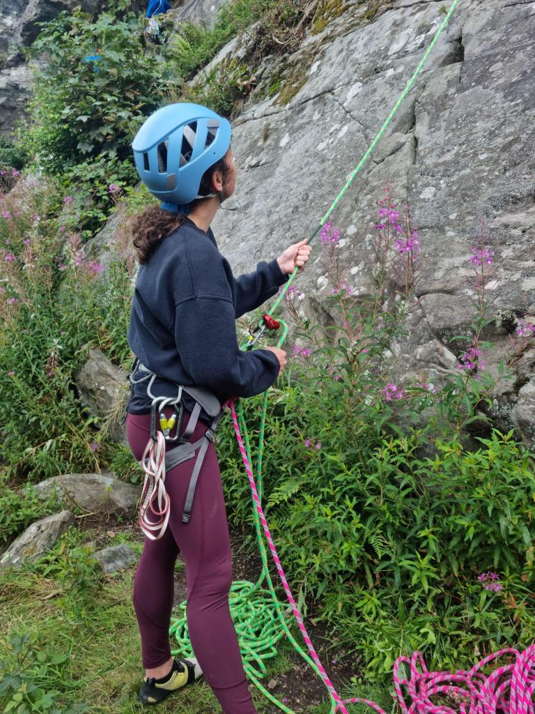
I was lucky enough to attend the 5 Day Discover Rock Climbing course at Glenmore Lodge with the support of The Neil Mackenzie Trust. I’d started to Rock Climb briefly before COVID but only ever indoor climbing, so I was really excited to take rock climbing outdoors and learn plenty of new skills along the way.
Glenmore Lodge itself was fantastic with excellent food and facilities (you can’t go wrong with a daily 5pm cake and debrief) and there was even an indoor climbing wall which our group used several evenings during the week – because can you really climb too much on a week’s climbing course?
There was four of us on the course altogether and the first two days we had one instructor, while the remaining three days we split into groups of two with one instructor per pair. The level of instructing and coaching was really amazing, and I thoroughly enjoyed the week.
The first day was an introduction to outdoor climbing; we went over skills as tying in a figure eight knot and best practise belaying from both the top and bottom of the crag. We climbed some nice routes in the Cairngorms and focused on climbing using our legs which was interesting as it wasn’t something I’d thought about much before.
Day two we headed to the Moray Coast to a small place known as Cummingston. Cummingston is a semi tidal sea cliff of soft sandstone; this type of rock was very different from the day before with some sandy topouts and we had some fun climbs. Today we were focusing on setting up good anchor points at the top of crags, we went over clove hitches and started to learn the techniques of setting up abseils and abseiling down routes.
Day Three was a big day and one my favourites. We split into our two smaller groups and went to Huntly’s Cave for a day of climbing where we got to experience our first ever multi-pitch with the instructors leading. It was a wandering route and I found it challenging in parts, so I was delighted to make it to the top.
Day Four we headed to Dunkeld to a nice crag known as Craig a Barns (Polney Crag) for some more multi-pitch climbs and practised setting up our abseils and abseiling down.
Day Five – sadly our last day! We headed back to Cummingston for some final climbs. We spent time focusing on placing gear as well as getting some good pointers and helpful tips on removing gear. After a day of climbing, we ended our course with some bouldering fun to round off a superb week.
A huge thank you to The Neil Mackenzie Trust for the opportunity to take part in this course. I learnt so much and I’m really excited to put these new skills into practise.
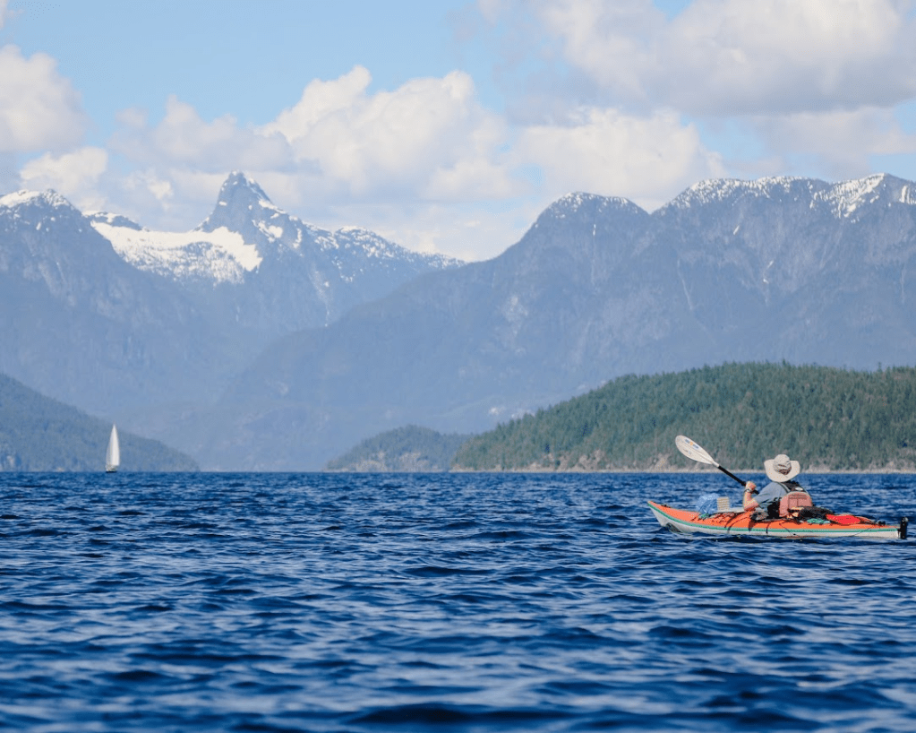
Before we begin, a shout out is in order to the Neil Mackenzie Trust and the VOC for putting together the Neil Mackenzie Adventure Grant. Learning about this grant for grand expeditions inspired us to dream up a longer combined kayak and mountaineering expedition than anything we had done before. We are grateful for their inspirational and financial support that allowed us to go on this trip. We are also grateful to live, travel through and camp on the unceded traditional territories of the Coast Salish People, including the Musqueam, Tsleil-Waututh, Squamish, Shíshálh, Tla’amin and Klahoose nation. In particular we would like to thank Chief Kevin Peacey and the Klahoose Council for giving us permission to go through their lands for our attempt on Mt. Champion, as well as go through their Ahpokum 9 settlement and land on the way to Mt. Denman. It is a beautiful place, so thank you.
Gabe By March 2021 I still had no idea what I wanted to do for the summer. I was dreading finding a co-op job and I didn’t feel much like taking summer courses. It had been a long lonesome year due to ~current events~ and I needed a break.
It was during this time that Eloise Faehndrich called me with the excuse I was looking for; her brothers and she had received a grant from the Neil Mackenzie Trust and were looking for a fourth to round out a kayak-mountaineering trip up the Toba Inlet. With very little in the way of kayak or mountaineering experience, I agreed immediately and stopped applying to any more co-op jobs. I would take the summer off to explore British Columbia and take the break I so desperately needed.
The Faehndriches are a sibling super-squad of ski-mountaineers, mountain runners, and general South Coast wanderers that put this whole trip together. I met Eloise in the fall climbing at the Aviary, and after a couple day trips touring in the South Coast, she figured I was fine enough to tag along for a longer expedition. Simeon, the eldest , took on the lion’s share of planning and preparation, and can generally be considered for the purposes of this trip report to be “the guy with the plan”. Finally, Tobias, the youngest of the team, was appointed stoke-master and cameraman-extraordinaire.
The plan was simple: drive up the Sunshine Coast and put in as far north as we could make it; kayak through Desolation Sound and up the Toba Inlet and bag a few choice peaks along the way. We settled on Champion Mountain, described as “an attractive horn” at the far end of the Toba Inlet, and Mount Denman, an icon of Desolation Sound.
Towards the end of May, we began eyeing the forecast for a 10-day weather window. We needed to be back in town by June 15th, but could see nothing but rain in the forecast. Instead of waiting around for some sun, we decided to head up the coast a few days earlier in order to pad the trip with a couple of buffer days. We booked a ferry for June 2nd and began our final preparations.
Day 0
The first shots on the expedition photo album are of Eloise attending her virtual graduation and finishing up cooking falafel for our lunch the next day. I had spent the morning fretting over what to pack for lunch on the last day of the trip, but I decided to go bold with a bag of apples and some peanut butter. The Faehndriches pulled up outside around 12:30pm and with a quick hug goodbye to my roommates we were off. We spent the ferry over from Horseshoe Bay trying to one-up each other by naming South Coast peaks from the sun deck. We soon bid our
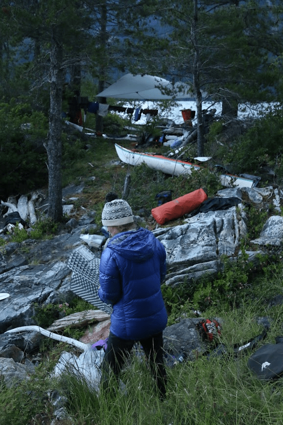
goodbyes to our friendly backyard mountains and looked north towards an unfamiliar range. There was a ferry announcement as we approached Langdale and we returned back to our car, Tobias with a rowdy sunburn. The remainder of the drive passed us by quickly, and before we knew it, we had pulled into our campsite for the night. When we arrived, we pulled everything out of the car and began sorting through our gear. Having never been on a sea-kayaking trip, I was under the impression that there was near infinite room for extra layers and camp comforts. With all of our bags piled high on a picnic bench, I realized that with mountaineering gear and 12 days of food it would be a tight squeeze into our boats. We walked around the campground and found a good spot to put in the kayaks. We then spent the rest of the evening playing cards, and pouring over our marine charts as we recapped our trip plan. That night we turned in early and fell asleep in anxious anticipation for days to come.
Day 1
It’s the first day of our adventure. In order to avoid paying for parking in Lund, Eloise drove me and Simeon 3km north and dropped us off at the kayak rental shop with all of our gear. She then beelined it back to Dinner Rock Campground to help Tobias pack up camp and load the boats into the water. Simeon and I rocked up to the rental outfit and I casually signed a statement stating that I am an expert kayaker and well within my ability to embark on a 10-12 day expedition up the Toba Inlet. The woman working the rental outfit offered us a free navigational chart of the area, but it only covered the first half of the first day and so we opted out. Simeon walked me through the basics of packing a kayak and helped me put my skirt on and get in the water. Lund, where we were getting into the water, lies 150km NW from Vancouver accessed via two ferries and the Sunshine Coast. Lund is the end of the road on the Malaspina Peninsula — this is where the Salish sea narrows and the islands of Desolation & Discovery begin (Quadra, Cortez, Savary, etc.) — as well as where the tides from N and S of Vancouver Island collide. Directly N of Malaspina are the Redonda Islands. Our route would take us up the narrow channel dividing West and East Redonda. On the far side of these impressive mountain-islands begins the Toba Inlet. This ‘short’ inlet tends NE back into the Coast Mountains for about 35km — at its head, the Tahumming, Klite, and Toba Rivers meet the sea. That was still days away though, and for now we paddled out into the bay and waited for Tobias and Eloise to make their way over from the campground. Once back together, we crept our way up the shore towards Sarah Point, the northern tip of the Sunshine Coast. The sun was out and filled our crew with unwarranted optimism for the days to come. Within a few hours of paddling we pulled onto a nearby island for a lunch break. Mmmmmm, yummy falafel wraps. Once back in the water we began heading again towards Sarah Point. As we paddled around the corner, we saw for the first time one of our main objectives.
Mount Denman stood tall and proud back behind the hills of Desolation Sound. With a sheer bald face, we could see no indication of how we could manage a 4th class route to the top. The exposure made me shudder and I began questioning my chances of making it to the summit. As we paddled on by, we began discussing whether or not we should go up with avalanche gear. As we couldn’t see any snow on our expected route, we decided to push the issue back a week until we were actually preparing our way up. For now the rest of the Toba lay ahead of us, and Champion was waiting. We pulled into Roscoe Bay, our campsite, at around 7 that evening. We had paddled 33 km that day and realized that our daily target of around 30 km a day was more than reasonable in fair weather. As soon as we unpacked, I dragged the boys back in the water to see if we couldn’t roll a couple of kayaks. Eloise stayed up on shore to relax and watch the going-ons in dry clothes. I went first, tipping myself over and immediately self ejecting after struggling upside down for a couple of seconds. It had been several years since I had been in a kayak, and several more since childhood when I had actually learned the technique. After talking it through with Tobias and Simeon a couple of times, we nailed down the combination of paddle movement and knee pressure needed to pull the kayak back over. I managed to make it up a couple of times and let out a good holler across the bay. Simeon managed to get it through once, and Tobias just barely missed the mark. Would I actually be able to roll a filled kayak if I flipped out in the open ocean? Probably not. But it was good fun while the sun went down and helped boost my confidence on the water. As Eloise contented herself with relaxing on the beach, the tide slipped her kayak from the shore and it drifted aimlessly across the bay. After much excitement and self ejects, we paddled back into camp and dragged Eloise’s kayak back up to shore. We talked over the plan for the next day, made some food, and got into our beds. It was quite a nice first day out on the water.
DAY 2 Simeon woke up that morning at 5am. He was interested in getting up to the peak of our lonely island hideout and catching a good view of the mountains that lay ahead of us. Unfortunately for him, he took the wrong trail up and only made it a few kilometers before coming back to base. The rest of us made our way lazily to the picnic bench around 7 and began work on our first backcountry breakfast, pancakes! We resolved to be ready to go in 3 hours, and so took turns cooking and eating the delicious pancakes as they came off the stove. It was nearly 11:30 by the time we packed up camp, but the pancakes were oh so good. The sky was looking a lot gloomier that morning; Juneuary was upon us and was here to stay. On our way out from the bay we passed by some yachters that encouraged us to check out some pictographs along the west side of Waddington channel. As this was along our route, we made a note of it and began the long paddle north. As we paddled further, the weather continued to sour. But as it began to drizzle, a wind picked up from the south and began to propel us up the channel. At that moment, we wished we had kept the tarp a little closer at hand. We made quick work going up Waddington, and made our way towards Walsh Cove for a quick lunch. We looked around for any sign of pictographs but found nothing. It wasn’t until after lunch when we got back into the water that we found a few faint symbols painted along the walls of the cove. With a lil more wind and a few paddles more, we made it to our camp early. We found a nice spot to spend the night at a log dump in Hepburn Bay.
DAY 3 It was finally time to make our way up the Toba Inlet. The walls of the inlet rose steeply to either side of us and were adorned with dozens of waterfalls crashing into the banks below. We had studied the marine charts closely and knew that just a few meters from either side of the inlet the ground below us plunged several hundred meters below the water. Along the entire 40 km length of the fjord there were only a handful of spots that we could make an emergency landing. The wind was at our backs, and so we paddled on. What started off as a light tailwind grew stronger and stronger until it was howling all around us. Simeon quickly took out the rain fly, and with Eloise’s help, he fashioned a makeshift sail. They began moving quickly away from me and I realized that this might just work.
We decided to take the moment to grab a quick lunch as the wind continued pushing us deeper into the mountains. We racked up four of us alongside one another, with me and Simeon on the outside holding up a paddle and the sail. The middle two busied themselves preparing naan bites and feeding me and Simeon as we struggled to keep the sail high. In this way we cut out close to 8km of paddling for the day. As we finished lunch and disbanded our makeshift sail raft, the winds were still strong and the water was getting dangerously choppy. All along the Toba huge curtains of rain rushed past overhead. We could see the wall of rain slowly catching up to us from behind, and then we would suddenly be thrown into a violent storm as the waves knocked our boat and wind and water blinded us. But then, just as quickly as it came, it moved on. We were suddenly in still water. Despite the storms, the wind had brought us to our campsite by early afternoon. We decided to seize the daylight and push on to the end of the Toba. When we came to the end of the Inlet, we were surprised to find an active logging operation. Trucks, people, and helicopters were busy at work in this outpost in the middle of nowhere. I think it took away some of the charm of the remote expedition we had hoped for. But if there’s one thing you can always count on in British Columbia is that wherever you go no matter how remote, a logging company has already beaten you to it. We pulled up on a swamp along the edge of the Tahumming River and began stashing our gear. This land, along with the start of the trail up Mt. Denman, belongs to the Klahoose Nation from which we received permission to access. From here we would attempt our first main objective of the trip: Champion Mountain. We set up camp and got out ingredients for backcountry pizza. I rolled out some dough and allowed everyone to customize their toppings. We turned the stove to low and took turns baking our pizzas one at a time. While we waited, we began joking about whether the logging operation had cut a nice road all the way to the alpine for us. We were excited at the prospect of an easy walk up, and so we set our alarms an hour later than usual, as a treat.
DAY 4: At about 5am I woke up to the sound of logging trucks making their way up the valley. I quietly wondered if we couldn’t hitch a ride to the alpine, and shortly fell back asleep. In the morning proper, we slowly packed up camp and tied up our food high in a tree. We ensured our kayaks were safely stowed and climbed out of the swamp onto the road. The logging road was well maintained and we excitedly marched along at a rather quick pace. About an hour in, while we were discussing whether we could make it to the top that day, the road abruptly ended in a dense and deep forest. The trail seemed to continue on however, picking it’s way deeper down the valley along the remnants of a long abandoned logging road. As we continued on, the trail became more and more overgrown until we were fully bushwhacking. This wasn’t going to be an easy jog up into the alpine as we had hoped. Our pace dropped dramatically, but we marched on. By late morning we had reached a tricky to pass river that blocked our way forwards. I was bracing myself on a log while trying to hop across some rocks when the log broke and I dropped my backpack in the rushing water. It was quickly swept downstream and I leapt through the water trying to get a hold of it. Tobias managed to fish it out of the rapids, and I continued downstream trying to catch my hiking pole that was floating on down. When I finally made it to the other side with a soaked-through backpack and my hiking pole, I realized I had dropped my absolute dearest water bottle. It might sound silly to you, dear reader, but this bottle and I had been through hell and back all across the world, and I was pretty bummed out. I also felt pretty silly and pretty lame having fallen into a river and possibly jeopardized our peak attempt. Luckily, that morning I had stuffed my sleeping bag, bivy, and mattress in a large plastic bag and everything that needed to be dry stayed dry. With a little excitement out of the way, we soldiered on. Soon we turned away from the river valley and began the slow ascent up and out towards the unnamed alpine lake below Champion Mountain. Our pace slowed considerably, and at times we were only moving a few hundred meters an hour. It was brutal work. At one point we veered towards another old logging road marked on our map, hoping for easier travel. I was leading the pack, and completely missed the “logging road” as it was so overgrown. When the rest of the crew tried to tell me that I had walked right by, I very confidently proclaimed “This isn’t a logging road, y’all are way too optimistic.” When the embarrassment passed, we tried following the derelict trail further up the mountain, but made very little progress. The bushes were thick and impassable, we couldn’t see our feet, and our arms and faces were bloody and red. We grabbed lunch during a rare moment of sun, and Tobias explored a possible alternative path to get us some elevation. He reasoned that we could climb up a creek washout and gain a few hundred meters and try to cut out a few switchbacks of the overgrown road we had been following. He managed to convince us one by one, promising bars and some extra packets of apple cider if his path proved to be more miserable than the last. Luckily, the washout was easier travel and we made it to about 600m of elevation by 3pm. We were planning on camping near 1100m. After the washout ended, we got back into the bushwhack for another few hours. As we rose higher and higher, we entered a large valley. Perfectly smooth granite faces reached down and kissed the forests on either side of us. The boundary between valley forest and granite faces was littered with avalanche debris. After evaluating some overhead hazard, we jumped onto the debris field and out from under the oppressive bushwhack and quickly gained the remaining elevation towards the alpine lake.
Eloise Bushwacking is not the right word to describe it, that conjures up the image of nicely walking through bush, with a couple of branches whacking you in the face every now and then. That is not what this was. It was full on bush-battling, bush-wrestling. As we made our way onto the debris field where we finally got a respite from the bush, I was pretty drained and beat up. I was plodding tiredly along, when I caught my foot on a rock, and my arms flailed to help me regain my balance. In doing so, my elbow hit the bear spray that was hanging from the side of my pack. Unbeknownst to me, the bear spray’s safety valve was broken, and I got a face full of bear spray in my eyes and nose. Everything started stinging. Yup folks, that’s the reality of the backcountry, things aren’t always idyllic.
Simeon It was absurd.
Gabe Towards 1000m the trees thinned out and the snowpack grew deeper. We found some bare ground and some trees to set up a tarp and cut out a tent pad. The alpine lake sat just about 5km east of Champion Mountain. A ridgeline encircled the lake from all sides. We figured we could access the ridge from the south side of the lake, follow it west towards a glaciated saddle, and pick out the final ridge that we could follow towards our summit. With a plan in mind, we got to bed and set our alarms for 6am.
DAY 5 I awoke to the sound of rain. Soon after I heard Eloise yell out: “6:30?” “Sounds good,” I said and went back to sleep. A half hour later it was still raining, so we decided to not delay any longer and go with the weather we got. It was incredibly hazy and I could no longer see the lake below, let alone the ridge we were supposed to gain. We ate breakfast quickly and began making our way to the south ridge. The snowpack thinned out a few times over the smooth granite faces, and so we carefully traversed these sections one at a time afraid of taking a ride down to the lake. We followed a GPS track closely as we aimed towards the glaciated saddle. The rain had lessened but the clouds did not, and we continued blindly circumventing the alpine lake below. At this point I felt my knee begin to give me some trouble. I’ve always had some knee problems, but the grueling bushwhacking from the day before really set things off and I began to fear that it was only going to get worse through the snow. Once on the saddle I spotted a protected boulder field and I got Tobias to take a GPS waypoint. Although I could keep moving, I was worried about my ability to self-extricate as we moved into steeper and more dangerous terrain. In case I couldn’t go any further, we found a safe spot for me to wait out a summit attempt. Only a half hour later, we came down a wide snow field and I could see up ahead that we were about to gain the proper ridge. With each step I could feel my kneecap screaming and so I told the crew that I was at the end of my attempt for that day. We stopped for lunch and discussed the plan moving forwards. We split up the Sat Phone and an Inreach between us and made a rendezvous plan. In case of delay, they would have to contact a third party through the Inreach which would then have to contact me on the phone. It wasn’t a great plan, but we had no way of direct peer-to-peer communication and so this would have to do. They would go on ahead without me, and I would follow our steps back to the pinned rocks and safely wait them out.
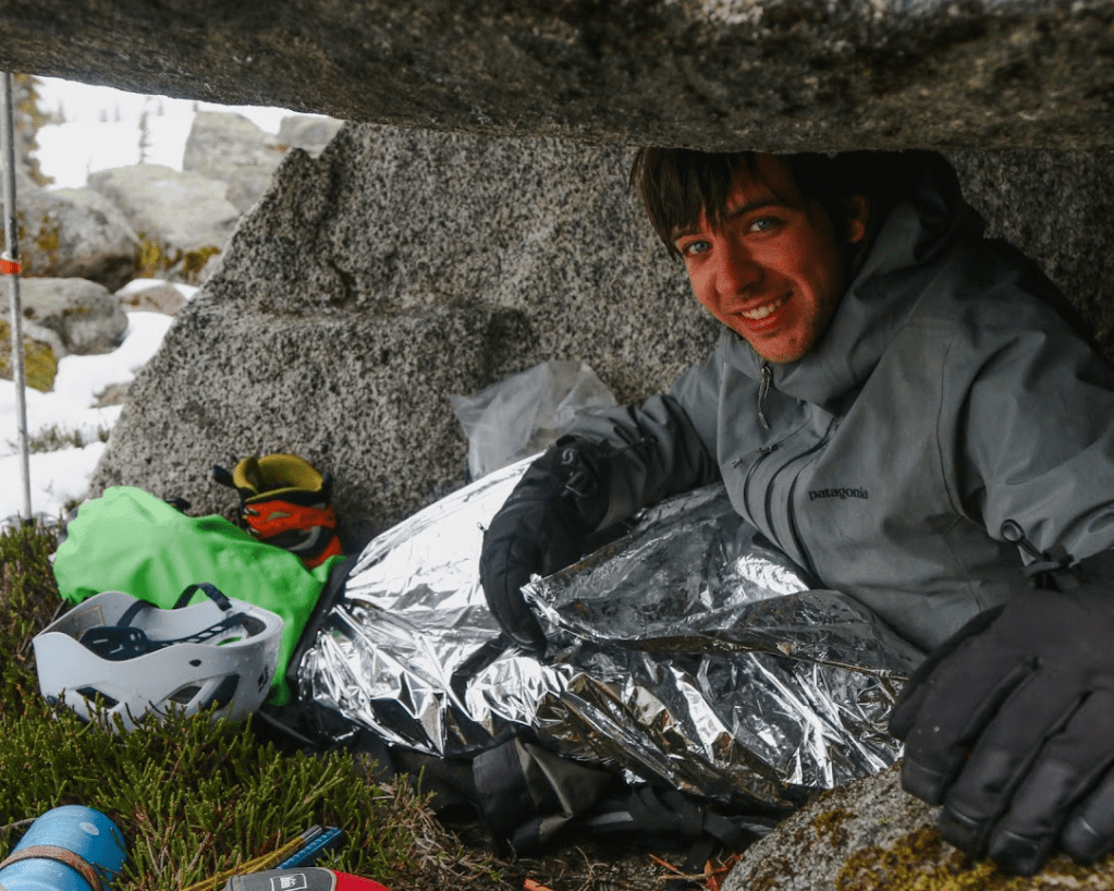
I felt pretty disappointed by the whole affair. I knew that I could push through the pain and continue making it up the ridge, but I was unwilling to push my luck in such a remote area. From where we stopped for lunch I knew I could very easily and safely make it back to our predetermined bivy spot. We were about to enter some more dangerous terrain, where turning back would require the entire crew to retreat alongside me. As the tag-along for the trip, I didn’t want to risk jeopardizing a summit attempt, or trying to push through the pain and consequently putting myself and my crew at risk. As we wrapped up our lunch, I said goodbye to my friends and very slowly made my way back to the saddle. When I got to the rocks, I walked around to some standing dead trees and collected a couple twigs and branches. I figured that it might get cold sitting about for a few hours, and I had a fire starter kit in my first aid kit that could help later on. I found a perfect one-man wide cave among the rocks and began setting myself up to wait out the crew. I put my poles and axe outside the cave to mark my spot. I then emptied my pack and laid it down flat, put on all of my layers and lay upon my bag. I took my wet boots off and wrapped my feet in a t-shirt and then stuffed them in a dry-bag to keep them warm. Finally, I pulled out my emergency heat blanket and wrapped myself in an airtight cocoon. As soon as I was happy that I would stay warm and dry, I felt myself dozing off and gave in to the feeling. I awoke about an hour later, and wondered if the visibility had improved and if I’d be able to see more of the mountains around us. I got up and saw that the light rain had turned into a blizzard and snow was howling all around my cave. Inside was still toasty warm, and so I retreated back into my cocoon and chilled out for the next few hours.
Eloise We were hesitant to leave Gabriel alone on the mountain, but he felt comfortable with the short route back to the hideout we had scoped out earlier, so we decided to give Champion a go. Right before we left, we checked the weather on the InReach and VHF one last time, and it was nothing but bad weather, with a potential for thunder and lightning. Although that wasn’t encouraging, we felt like we had to at least check out the ridge and see what it was like. From the GPS we could see we still had a couple mellower subsummits to go before the true summit. As we trudged along, alternating who broke trail, it started snowing lightly. We made it up the first sub summit, then the next.
Simeon For the most part a decadent plod, once you stopped thinking about the bizarreness of what we’d been through for this snow-globe, it was really a very atmospheric crest of land we were on. The thick silence held on, the late season cornices took on the appearance of decaying sandstone tectonics bleached by another world — for all we knew we were on the very edge of that world (where were we anyways?); white then black blended down to dull gray in the catatonic mists below. Yesterday we had come out of the rotting organica ‘to lay down and die for’; up here, the mind was brushed by visions of bare bones and absence, where materiality might finally broken down, dissolved, could be… The crest rolled on like a frozen wave. Nothing now, but to sail on drunkenly and gloriously, up and down, up and up and up.
Eloise The snow started coming down heavier as we made our way down to the col to the final ridge up to the summit. As I started going up the first steeper section, I triggered a small point release avalanche, which caused me to pause. We talked about it for a minute, then decided to keep going, saying that when you are walking in steep fresh snow, you are bound to release small stuff. Two minutes later I saw in front of me some snow fall down a chute that was further ahead and on the side of the ridge. This made me come to a full stop, and we decided we needed to have an actual discussion about the risks and whether we wanted to keep on going, instead of half talking about it, and then just keep on going because of group-think mentality where no one wants to be the one to say we should turn around. So we talked about it. We listed the facts: a human-triggered point release had been set off, a non-human avalanche had been released, it was snowing, and conditions were deteriorating by the minute, the only forecast we had was for worsening weather and potential thunderstorm, we were in a remote area where help would be hard to come by, so the consequences of getting injured were worse. We also debated whether what we saw could actually be considered an avalanche, or if it was just snow falling from the ridge because it was steep (that specific steep couloir where the snow fell was not where we would be going). We discussed how we didn’t want to feel pressured to peak just because we had done a lot of work to get where we were (3 days of kayaking and a brutal bushwack). In the end, Tobias brought up a seminar by Cody Townsend that he had watched on ‘the normalization of deviance’. He said that we could probably go up and be fine, but did we want to risk it on a probably? And even if we did make it up and back down alive, would that be the right decision? We didn’t want to normalize bad decisions just because we might come out alive afterwards. Finally after 10 minutes of talking in the thick snowfall, we decided to turn around. As we headed down in a whiteout, it felt like the right call.
Tobias We shouldn’t be sad that we didn’t summit, but happy that we made the right decision and are alive.
Gabe By 4pm the crew was back and we began heading back to camp. Along our way the clouds started parting and we finally got a view of the mountains down along the Toba. Back at camp I used the InReach to communicate with my roommate back home and set up direct peer-to-peer communication between the SatPhone and InReach. Now we would be able to communicate with each other in the event that we needed to split up again.
DAY 6
The next day we woke up to glorious sunshine. The irony was not lost on us, but we had no more food left and plenty more days ahead of us. We packed up our tents to begin the long bushwhack down. As we navigated along the avalanche debris, a fridge sized ice block that I was leaning on came loose from the wall and fell on top of me, taking me for a bit of a slide on the granite. I caught myself and managed to get out from under the ice block without any injuries. Clearly I needed to be much more careful as the sun was weakening the snow.
Eloise Gabe is summarizing this very casually, but I think this was the closest call on the whole trip, and could have led to debilitating injury if he had randomly been 30cm closer to the block. It was one of those things that was completely out of our control, and it was scary.
Simeon At this point morale was low, so I suggested revamping our trip by a small but handy proposal. I put forward to rename our expeditionary force upon the unifying theme of J.O.H.N.; I was to be John Clarke because I liked long traverses, Tobias, John Baldwin because he was an extraordinary backcountry skier, Gabe, John Long because he went on all these crazy adventures, and Eloise, long johns because she always got cold too easily.
Gabe The rest of the way down was much easier than we expected. We didn’t so much as hike down but slide and fall using the bushes to slow our descent. As we began cutting down to the valley bottom towards the Inlet, I asked the crew if we could make our way down to the river where I fell in for one last sanity search for my bottle. When we got down I threw down my pack and started heading downstream looking. I found it! Precariously pinned up against a rock in the middle of the water flow. I have no idea how it lasted 2 days and a continuous drizzle, but Tobias reached over and grabbed it out of the water and I took a victory swig of still fresh water.
When we got back to our camp, we ate some lunch and began to transition into our water gear. We bade goodbye to our inlet end and began paddling towards a small islet about 10km along the bank. This rocky little island was only about 30m in diameter and only had space for one tent. Along the way our beautiful sun disappeared and was replaced by the strongest winds we’ve encountered so far. Our tailwind was now a headwind and we made very little progress battling the waves down the Toba. Without any other beach at which to park and wait out the storm, we pushed on against the winds. The islet had no beach on which we could easily dock our kayaks, and so we had to climb onto the bluffs and unload the kayaks while they floated beside us. It took us a while to safely get everything onto shore, but we were rewarded with an astoundingly cute little campsite. We tried to spot Champion up the valley, but the mountains disappeared into the clouds and we could see nothing.
DAY 7
The next day we paddled up the remainder of the Toba and found a beautiful campsite right along the mouth of the Inlet. We got to the beach early and spread all of our stuff out to dry. We were only able to relax for about an hour before the tide began to come in and we realized that the entire beach and all of our gear was about to be submerged. We scrambled to get everything to a high point and resumed relaxing. Eloise began reading us trip reports from the VOC Journal that she brought along. We were particularly jealous of a report in Desolation Sound that claimed to have beautiful weather and an abundance of whale spotting. We laughed at our luck, but enjoyed all of the trip reports nonetheless. I was once again on dinner duty, and once again I was baking bread. This time, I fried potatoes with olive oil and an assortment of spices and then stuffed the medley into pockets of dough. I then fried the dough on the stove and enjoyed my backcountry version of Aloo Parathas.
DAY 8
Just another travel day. We had officially left Toba Inlet for good and we were now headed straight for Denman. The water was still, and we were happy to get out from under the Toba storms. We pulled up to Forbes Bay in the early afternoon and started to transition into our hiking gear. Once again we stashed our kayaks and began the long bushwhack towards the alpine. There was no logging road this time around, but we managed to find some intermittent flagging that led us along the valley floor. There was much less bushwhacking on this approach, but the forest here was much older and so travel was still slow. The ground was covered in a thick layer of moss, and I continuously fell through random holes in the forest floor. We crawled over hundreds of rotting trees that just crumbled under our weight. It was weird being in a forest that felt so alive but also felt so very decayed. It felt more like walking through snow than ground, but we continued following deer trails until 6 or 7pm when we found an acceptable camping spot. There were no flat spots, and everything was lumpy and covered in moss, so we made do with what we got. I was lucky to have a bivy that I could set up essentially anywhere, but the rest of the crew slept lopsided and all piled up on top of each other in their tent.
DAY 9 We continued hiking along Forbes Creek until we reached about 250m of elevation. From this point on we turned north and began the steep ascent towards the base of Denman. The moss was deep and steep, but the way up was much less bushy than Champion and so we made good time. A few sections required us to navigate around some cliffy bluffs, but we made it to the base of the ridge at 1260m by 2pm. From here we decided to get onto the ridge and try to find a camp spot near 1600m from which we could make a summit attempt in the morning. Once on the ridge, we started encountering some 3rd and 4th class moves and began reevaluating the possibility of finding a camp spot further up. We were soon getting onto some 5th class terrain and we decided that it might be worth it to take a moment and scout out the route ahead before we committed ourselves to coming down more low-5th class moves with our large packs. Eloise and I dropped our packs and went left around the west side of the ridge and to our surprise found a 3rd class route back down to where the terrain became 4th class. I was pretty anxious about having to come down what we had ascended, and so I was incredibly happy to find an easier way back down the ridge. Simeon and Tobias continued up the ridge. The next section they described as a 5th class corner where you pulled yourself up along blueberry bushes while holding your boots flat against the wall. When they reached the top they found a rap sling. From there it looked like the route continued east around the ridge up some more 4th and 5th class scrambling. We regrouped 15 min later and decided that it was unlikely that we could find a camp spot further up. We followed the route Eloise and I found back down to the start of the ridge to set up a camp for the night. Before packing it in, we decided to hike up the alpine bowl west of the ridge to see if we could find a safer way onto the face of Mt. Denman. We got to 1400m and found nothing [of the access Bivouac had reported at this elevation], and so we turned back to set up camp at the base of the ridge. We checked the forecast for the next day and saw that it was supposed to rain all morning with a possibility of sun in the afternoon. At that point, I was well aware of my own scrambling limitations and decided that I was not comfortable with 4th and 5th class scrambling in wet weather and far from solid rock. Once again I felt a responsibility to my group to stay back while it was still safe to do so, so as to not prevent my partners from reaching their goals. Once I decided that Denman was not for me, we began to discuss the rest of the plan. Now we had two devices that could communicate with one another, which made it much easier to alert each other to any cause for delay. The crew would wake up late tomorrow and try to catch a weather window and avoid scrambling on wet rock. Going up later in the day meant getting back to the kayaks a day later than we expected. We figured we had enough bars and extra snacks to ration out an extra meal and felt good about our plan for the day.
DAY 10 We slept in till 8am. I stayed in my bivy and listened as the others got out and started preparing for their day ahead. As they started towards the ridge, Tobias came by and we confirmed the plan with each other. They would be back by 1pm. I listened to them leave and stayed in my tent a little while longer. It was still drizzling, and I felt happy to be safe and down. I spent most of the day reading and just wandering about camp. Close to 1pm I got a message saying that they had made the summit, but that they’d be another 3 hours back down. I was pretty psyched to hear that they made it safe and was happy to hang out around camp for some more time.
Eloise We left the campsite and started retracing our steps from the day before, up onto the ridge and past the location that Tobias and Simeon had scouted up to the day before. At 1550m we got to a shoulder that was flatter (a decent camp spot, future mountaineers) and from which we knew we would have to traverse up and climber’s right. We had read trip reports about this section, and heard of a fabled ‘sidewalk’ slab that, if found, made the ascent much easier.
But everything we read had been rather vague, and as we looked around at the mass of rock and snow in front of us, we could see nothing that resembled a sidewalk at all. It was June, much earlier than any of the trip reports we had read, so we figured it must look different, and we would just have to figure our own way up the mountain, based on what looked best in front of us. The weather was a little drizzly, and looking at the rock that went up from where we were, I wasn’t too keen on downclimbing it if it was full-on raining. But the weather report we had looked at earlier said it was supposed to clear up, and so we figured worst case, if it was raining when we got back to the top of this section on the way back, we could huddle and wait out the rain. We went slowly. Carefully placing one hand, before moving a foot, then the other hand. It was 4th, low 5th climbing, it was wet, and I didn’t want to fall. I fully expected that we wouldn’t make it, that we would be forced to turn around, like on Champion. The weather would clear up though, and we would get energized, and say that the window had come, so we continued forward. Clouds came in and out. We made it up to the next shoulder, from which we made steps up a snowy slope that led to a rock ridge. The moves were spicy, I was pretty nervous at this point, mostly because it was pretty sustained high class scrambling in wet conditions. I thought about how, if the weather soured, the return would be even sketchier. Simeon and Tobias were leading, and I slowly trailed behind them, having an internal debate whether I should stop and just wait for them to come back, or keep going. Suddenly Tobias yelled out from the white out in front of me. “The peak is 30m ahead of us, the rest of the way is an easy ridge walk to the top!” It was only then that I knew I would make it, and it was pretty exhilarating finally having a successful summit after having to turn around on Champion, though I was still nervous for the descent. On the summit we took some quick photos in the whiteout, and sent a quick message to Gabe that we would be late (we had gone much slower than anticipated). On the way back we decided to take some snow slopes down instead of the rocky ridge we had come up, and it proved much easier. We carefully down-climbed the traverse and I breathed deeply when we made it back to the first shoulder, finally able to relax, because I knew everything from there would be much easier. We had made it.
Simeon She said it all. At this point I had zero expectations. Our pores were saturated. But that “weather window” was a fascinating detail. For now, though, all we had was each move as it came up before us.
Gabe When they got back to camp, they excitedly told me about their adventure and I was glad to hear of their exploits. We packed up tents and started back down the valley. By about 8pm we made it to our campsite in the moss from the way up. We passed around our bars and prepped for another night under the trees.
DAY 11 Tired and hungry, we finished the last of our bushwhack. We took our time to enjoy walking under the giant trees and to snack on salmon berries along the way. Once we got out to the beach, we faffed around for a while. We dried our gear and soaked in the sun, which was cheekily poking its head out after a notable two week absence. We kayaked for a short while to the Curme Islands, on which we were the only inhabitants for the night. We took the opportunity to take a group picture, during which was the only time any of us put our crampons on for the entire trip. During our photoshoot, the rain came in quickly, so we packed up our gear and made for our tents. I spent my final night swinging in my hammock, peaceful and dry under a tarp.
DAY 12 We woke up relatively early that morning to make a beeline for the ferry. As we were packing one of the boys noticed a water spout out in the distance towards Redonda Island. It was whales! I was elated. They had come to see us home. By the time we were out on the water, they had moved north further up the bay. We turned south and said goodbye to the mountains that had graced us. I split off from the group and returned my kayak in Lund while the others went a few kilometres further south to pick up the car. I grabbed some cinnamon buns for the crew in town and chatted with the outfitters while waiting for my pick up. The ride home was easy. We made it to both of our ferries with very little trouble, and spent the time outlining the notes that would end up making this trip report. We chatted mindlessly about the trip, and trips to come. The Faendriches were figuring out how to get up the next inlet north. I came home to an empty house. I pulled out all my gear onto my living room floor, took a shower, and crashed.
It was an early start for me for a Monday morning sitting in my haar surrounded flat in Fife. The excitement and anticipation of a week’s training in the mountains however kept my spirits high. The forecast for my week ahead looked varied and unpredictable, which I took as a positive sign as I wanted to complete my training in a plethora of conditions! Driving north up the A9 the weather continually varied between lovely sunshine and short showers. On arrival to Badaguish Training Centre within the Cairngorms National Park I was greeted by my tall and hugely experienced course leader Johannes. Our training group consisted of six very keen individuals from all walks of life. However we all strangely came up from the Edinburgh area.
Our First day started with a briefing of how our week ahead would look and also some questions from around the group finding out what we all wanted to get out of the training. After getting to know each other a little and sharing past mountain experiences it was time for a little walk up Creag Gorm and Meall a’ Bhuachaille for some laid back nav practice and working out our timings and pacing. After a good 4 hours on the hill we returned back to the centre full of energy so our guide Johannes decided we would get in some basic rope work before the day ended. Having had indoor climbing experience, myself and some others found this section of training pretty straightforward and even after 10 minutes or so the whole group knew what they were doing!
Day two consisted of a proper hill day up Ben Rinnes with Mr Pete Hill, our course director. We meet Pete at the base of the mountain and readied ourselves for a day of navigation techniques, rope work and practicing the techniques required when dealing with difficult terrain. Pete’s teaching methods made this whole day fun and relaxed even though the weather consistently blew us about the hill. On our walk back down to the vehicles Pete taught us some amazing games which could be played with a group facing the prospect of a long slog back from a hike.
Day 3 was a day for getting wet! The weather was forecast to be terribly wet all day so Johannes decided this was a day to practice nav, first aid, emergency situations and since wewere wet already, river crossings! The day started at the upper car park near the Cairngorm Ski Centre. From here we all threw on our waterproofs and headed for the hills. The fact that a lot of the burns were currently in spate provided some very good conversation on risk and back up plans. After a while each member of the group was given a navigation leg in which only themselves and the course leader knew of. Correctly getting the group to the given location was nerve racking but fun and I’m happy to say each member of our group managed no problem! For much of the day we practiced using a verity of safey equipment such as bivvy bags, group shelters and making stretchers from rope. It was reaching 4pm when we got back to our vehicles and Johannes had one more thing for us to practice, river crossings! Johannes had a place in mind for us to practice however he took us up and down the river and sparked some healthy debate on what qualifies as a safe place to cross. After we chose a safe place to cross the inevitable nervousness and giggly throughout the group started! We all each took a turn in different positions within the group crossing the river and by the end of it no one could feel anything from the knees down! In happy and rejuvenated spirits though we all sat by the river for a briefing of the day.
Day 4 was a half day for us. A day of planning and preparation for the 2 day, 1 night hike and wild camp up in the Monadhliath Mountains. Fortunately our group was well prepared and decided that since we had a half day on day 4 we would all go into Aviemore for some pizza and a bit of group bonding.
Day 5-6 was the big one. The expedition. The weather was largely on our side with light winds, a little cloud and for our second day sunshine. We all met at a small car park just north of Newtonmore ready for our big day. It was good to see people with a variety of different sized backpacks and equipment. Mine being on the slightly larger side of things had me thinking id maybe brought too much! I always like plenty of layers! We set off sharp after a quick briefing and weather check. As in previous days each of us took a leg of the navigation and kept conversation flowing throughout. The day consisted of spotting a golden eagle, identifying flora and fauna, identifying distant peaks, bagging 2 munros (A’ Chailleach & Carn Sgulain) and finally setting up camp just below the summit of Geal Charn. After a brief stint in our tents we had a little dinner and waited till the light faded for the all-important night navigation. This consisted of finely tuning our navigation techniques and putting them to use in the pitch black of the night to properly simulate poor visibility. I was nervous about this section having never really done it before but when we got started I loved the logic and technicality of it! After some hours we got ourselves back to camp and threw ourselves in our beds after an exhausting day. The following morning we were greeted with calm and sunshine. We packed our bags and began the 3 hour stroll back to the cars. This was time of reflection, review and looking at the next step for each of us. Johannes completed our day with a bit of group and individual feedback which set each of our future goals!
This training was one of the greatest experiences I’ve ever had. It filled me with nothing but confidence in that what I was doing was the right thing for me. I met some wonderful people with whom I still have a Whatsapp group called the Monadhliath Moles (Inside joke) and cannot wait until I book my assessment.
I used to be a competitive slalom kayaker, competing in the premier division in the UK and ranking within the top 100. However when I made my move to Fort William to study Marine and Coastal Tourism I started to transfer these high quality slalom kayak-ing skills into sea kayaking. I initially did my first Sea Kayak Leader training as part of my Gold Duke of Edinburgh residential in 2017. However at this point an assessment was not on my horizon. Since then, I gained more sea kayaking experience and I thoroughly enjoyed this process as I was able to develop existing skills in effective sea kayaking leadership skills. When I made the move to UHI in Fort William I decided I wanted to re-do my seakayaking training to refresh what I had learned, now with the aim to do the assessment.
This training filled me with confidence and also gave me a few pointers as to where I could improve. At this point I had enough experience and was eager to do the assessment, I was in the process of booking an assessment when COVID-19 hit. In terms of my Sea Kayaking Leaders assessment this (COVID-19) ended up being a blessing in disguise as it allowed me to get further experience. During the first ease of lockdown restrictions I was on the look out for some work experience in sea kayak leading and an opportunity in Skye which I grasped with both hands. At this time assessments were not running, and therefore I had no choice but to get more experienceand retain the level of skills I had gained over the years. Getting this opportunity of work experience on Skye allowed me to work with qualified professionals who were able to give me coaching and pointers for improvement. Having this time to gain such experience was extremely precious as I then felt that I was in a far stronger position to sit my assessment when restrictions would allow.
Fast forward to May 2021 when lock-down restrictions were easing, I booked my assessment with the assistance of the Neil Mackenzie Trust. The day of the assessment changed multiple times due to a lack of conditions to effec-tively run the assessment. Eventually we settled on a day and location that suited therequirements of a Sea Kayak Leader Assessment. The assessment consists of personal paddling skills (Paddling skills, rolling in rough conditions and practical navigation skills), Safety and Rescue (rescuing other paddlers, self rescue and proficient tow-ing skills), Leadership Skills and finally Theory (tidal planning, weather, safety etc.). On the assessment there was one other being assessed along side our guinea pigs. We had to guide our guinea pigs around a small island. The conditions were perfect for the assessment and even going slightly above the remit, however this posed a good challenge for us as leaders. We were tasked with certain sections of the journey. I was tasked with taking our group across wind then surfing back into a sheltered bay. The conditions were growing at this point and I noticed one of our group needed some closer guidance away from some rocks, I was prompt in positioning myself in a place where I could guide them safely away and down into the bay. We were then tasked with using the conditions to find areas we could play on the waves with our group. I found a good point where larger surf-waves were forming near a headland, the group had great fun playing on these waves. Within the same task I was asked to guide our group through a gap in some rocks which had some waves in-between (Rock Hopping). Again the group enjoyed this.
To finish the assessment, certain scenarios were set up so that we could demonstrate our rescue skills. My scenario involved a group member falling out of their boat in a position where they may be washed onto the rocks. I decided to ask a group member to tow myself and the ‘casualty’ away from the rocks as I did the rescue, this involved emptying the capsized boat and getting the‘casualty’ back into the boat and back to safety. Finally, I had to demonstrate two methods of self-rescue, I chose to do a roll and a self-rescue called a re-entry and roll.The assessment was successful and I passed with the recommendation that I work towards my Advanced Sea Kayak Leader. With the support that I received from the Neil Mackenzie Trust I have now gained an extremely valuable qualification whilst also giving me a step-up into my future Industry.